
Destinations & Things To Do
Flexibility and Patience Early On
I’ll admit: I started out overconfident.
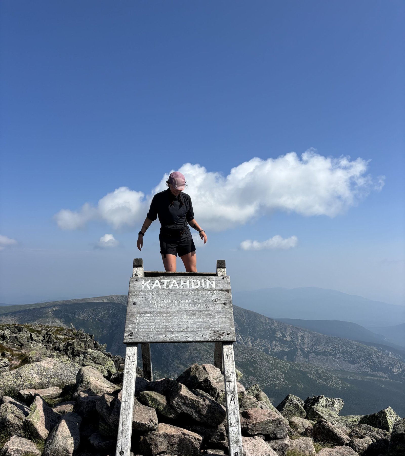
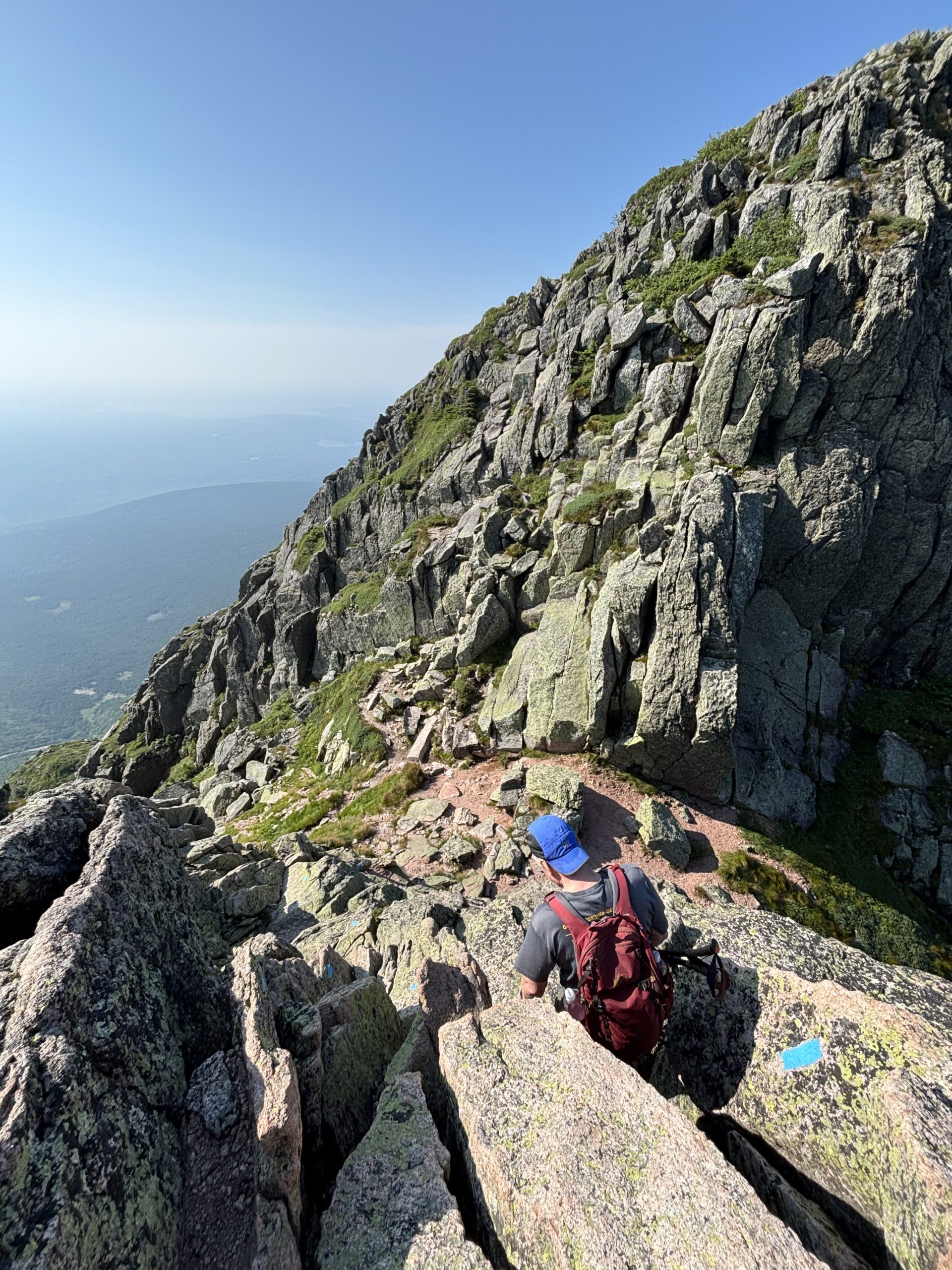
Getting to Mt. Katahdin, the northern terminus of the AT, went smoothly. My mom and dad drove the seven hours from Massachusetts to Baxter State Park with me, and we camped for the night. When we woke up at 3:45 a.m. the next morning to drive the hour and a half to our trailhead and start early up the mountain, the sun was already rising in a magical, glowy way. My dad hiked Katahdin with me, which I was grateful for since we decided to take the Knife Edge Trail up. I’ve been wanting to do this trail since 2018 when I summited Katahdin in the rain to end my first thru-hike.
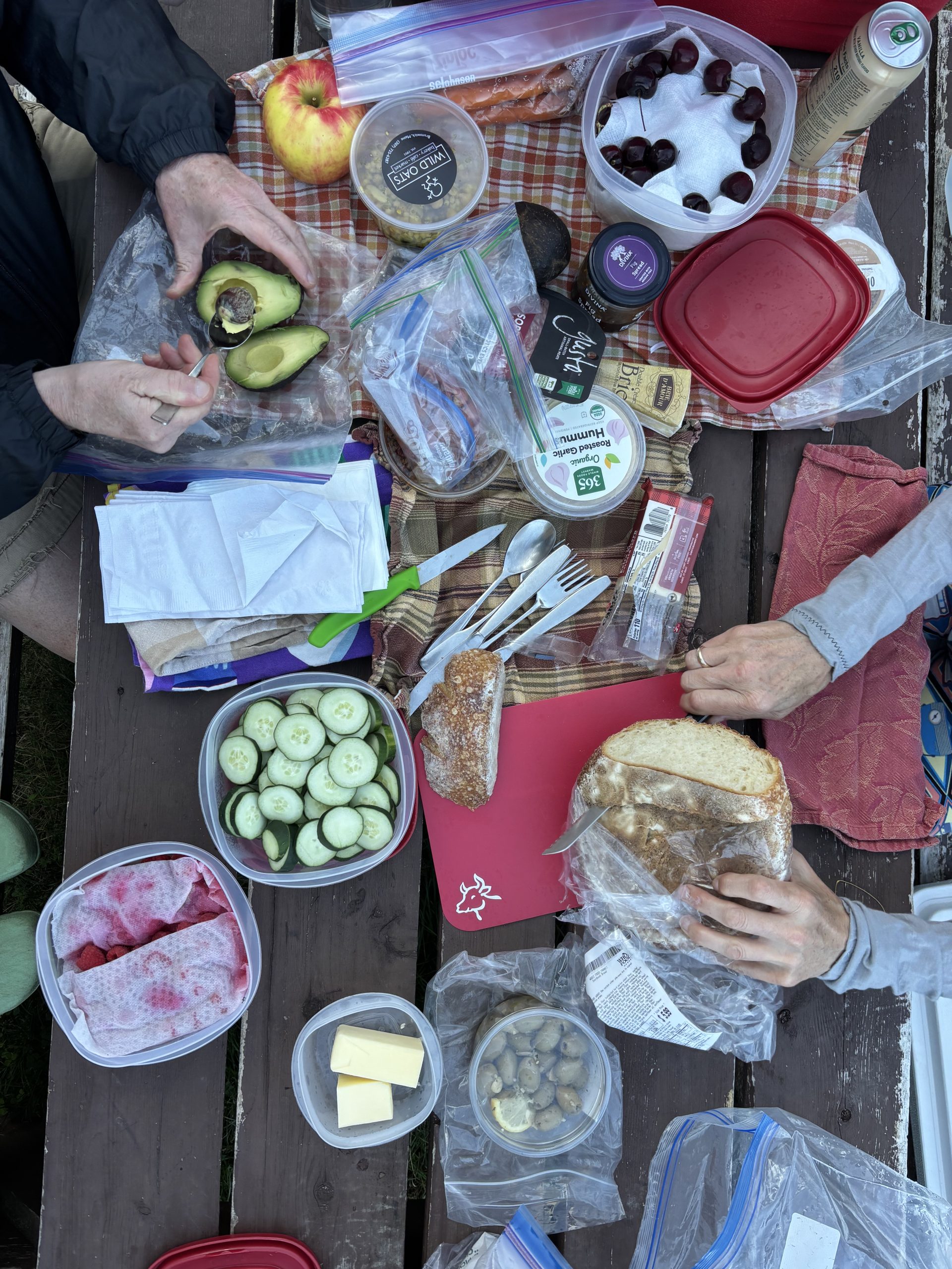
This time, my dad and I pranced up the scrambly rocks, taking in the perfect weather and clear views. We reminisced about our time up there seven years ago, and I had this overwhelming feeling that starting the AT is exactly what I’m supposed to be doing. We took photos at the sign and hiked down the AT to the base of the mountain where my mom was waiting for us with a picnic lunch.
It was hard to say goodbye to my parents as I walked off alone onto the trail, but not as hard as the first time I stepped onto the AT at age 19, hiking into the Georgia wilderness. This felt like a full circle moment. I could really reflect on the ways I’ve changed over the years since. I now had all different gear, a wealth of knowledge and experience with long distance trails, and confidence that I didn’t have back then.
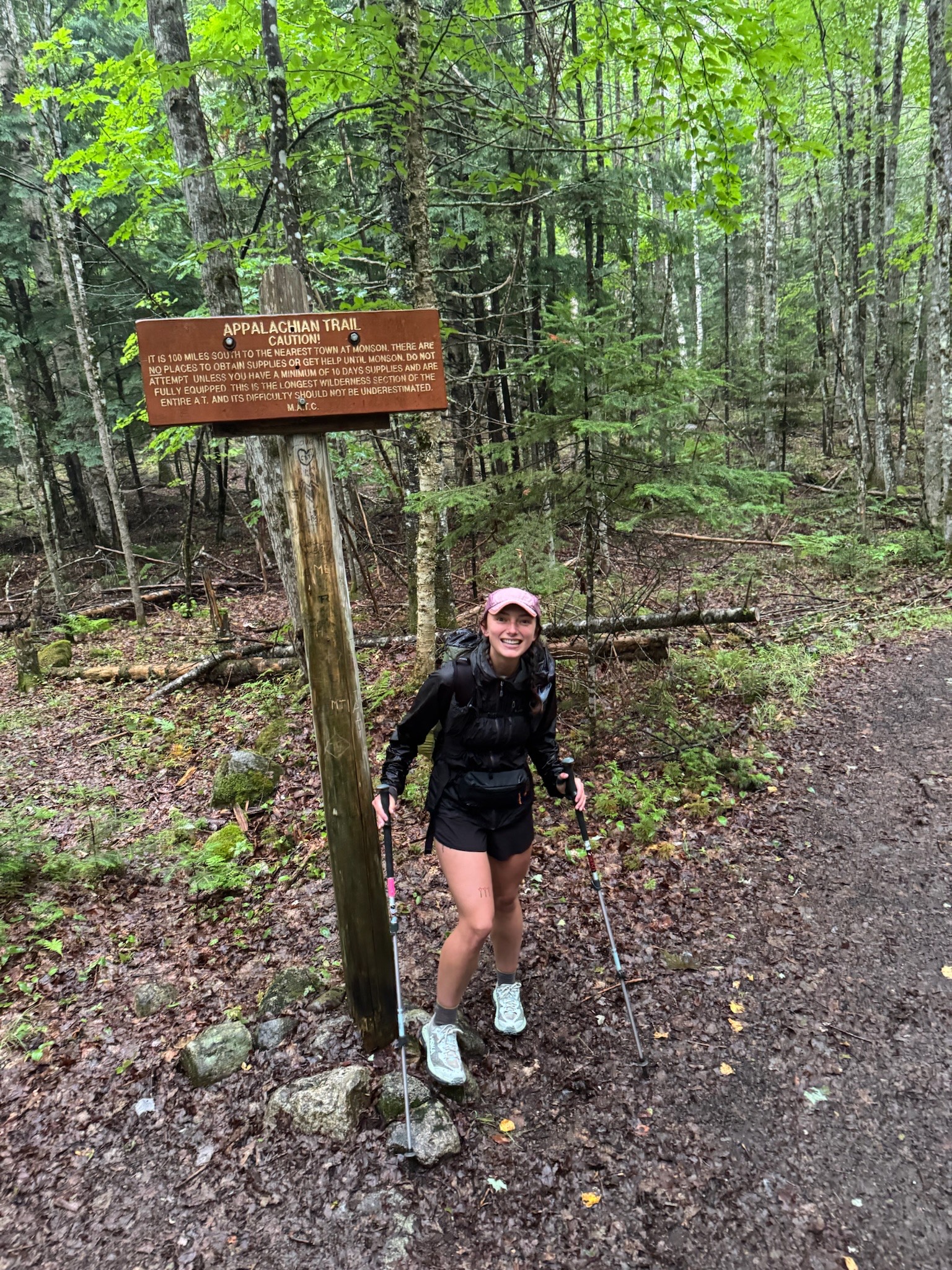
After summiting Katahdin, the official start of the AT, and descending the Hunt Trail, I hiked the 10 more miles to camp, feeling excited as ever to be out there. I slept like a baby, lulled by the soothing sound of rain on my tent. Day 1 on AT2 (my shorthand for this second go of it), done.
100 Mile Wilderness
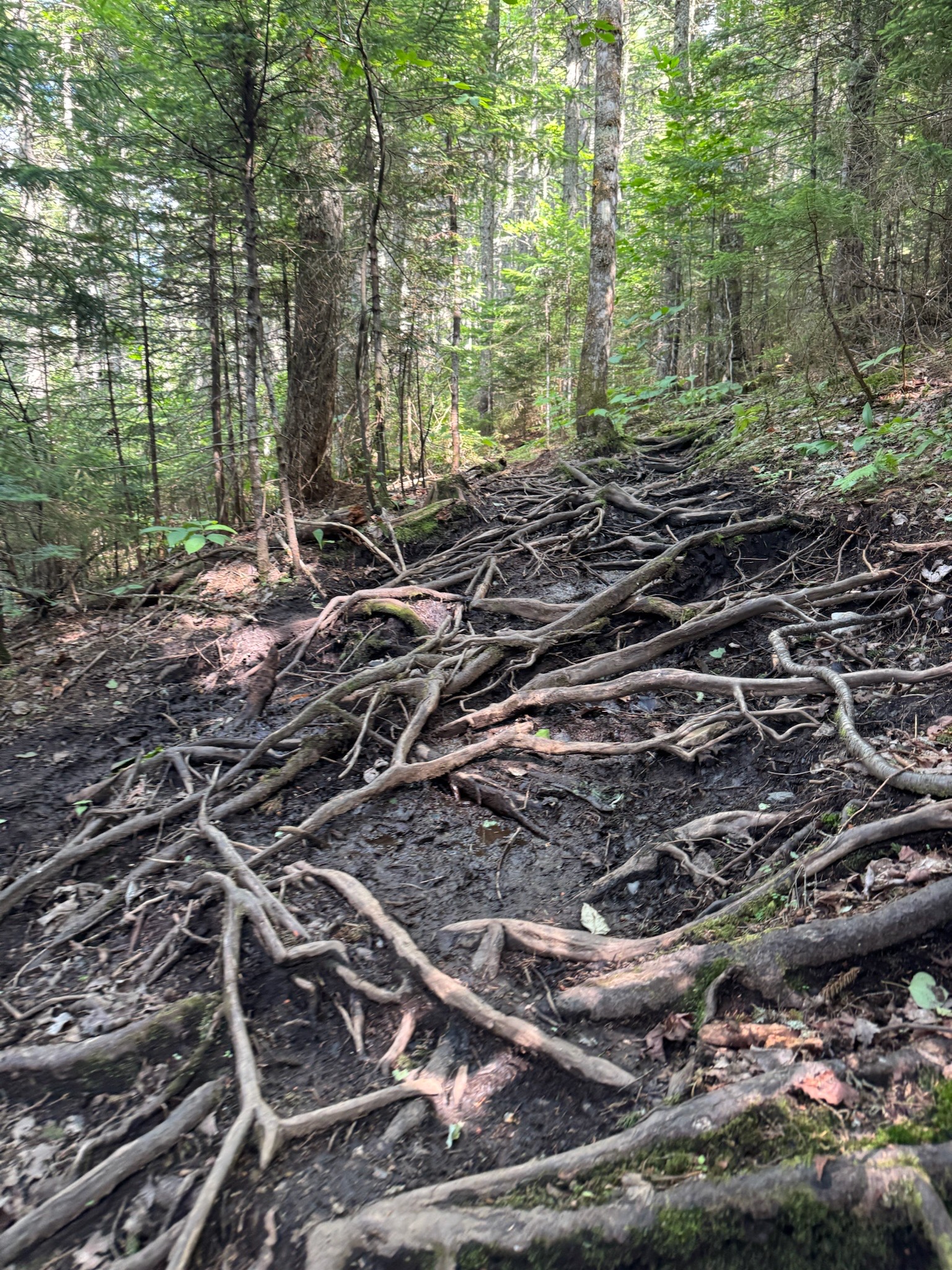
The next few days through the 100-mile wilderness went swimmingly (sometimes literally). Besides a little drizzle the second morning, the weather was spectacular: dry, crisp, sunny and cool but not too cold. I loved seeing the varying greens, mosses, rocks and bodies of water. I feel such a strong connection to these landscapes. I swam multiple times in the pristine lakes, crushed the miles, and my body felt surprisingly fine. Because I’ve been nursing a hamstring injury for several months, I haven’t hiked more than 13 miles since my CDT thru-hike last summer. But out here, 25-28 miles a day was feeling great. I was tired but in a good way, and I was feeling so proud of my body.
Things changed on day 4. Getting near the end of the 100-mile wilderness, I hiked 28 miles with almost 8,000 feet of vertical gain. If I’d had my “trail legs” (thru-hikers’ term for when our bodies get accustomed to the daily physical and mental demands of the trail), this would have been fine. But unfortunately, for the beginning of a hike with the minimal training I’d done, these big days were too much. The next morning, I started to feel pain in my knee. I tried to ignore it for a bit, see if it would pass. But it only got worse with every step. Eventually, I decided to be smart and accept a ride to town from a dirt road 11 miles from the end of the 100-mile wilderness. So close.
Feeling failure
I’ve dealt with plenty of overuse injuries, but each time feels just as heartbreaking as the last. I felt stupid, thinking, “if I had just done this or that small thing differently, this wouldn’t have happened.” But the reality is that an overuse injury like this at the beginning of a thru-hike is incredibly common. There is no amount of training that can truly recreate the challenge of rugged Maine trails, especially doing big miles. There is no way to practice walking for 12 hours a day in normal life. So of course it’s an adjustment for the body.
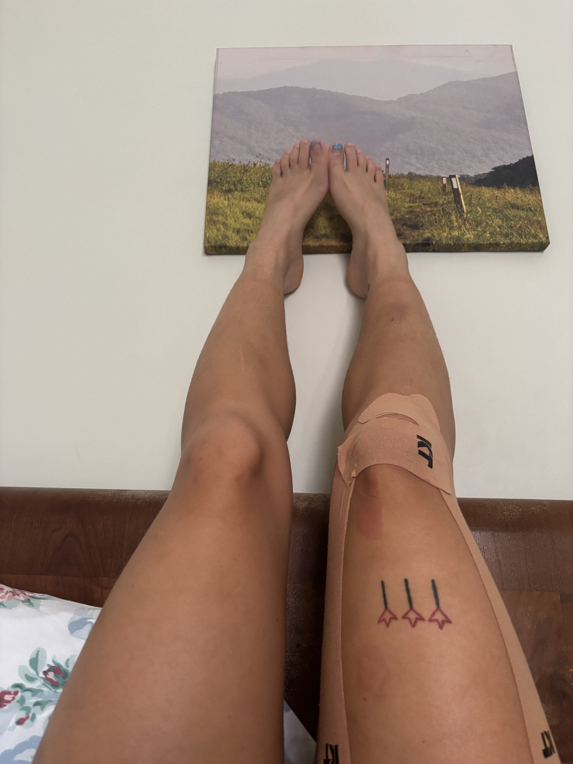
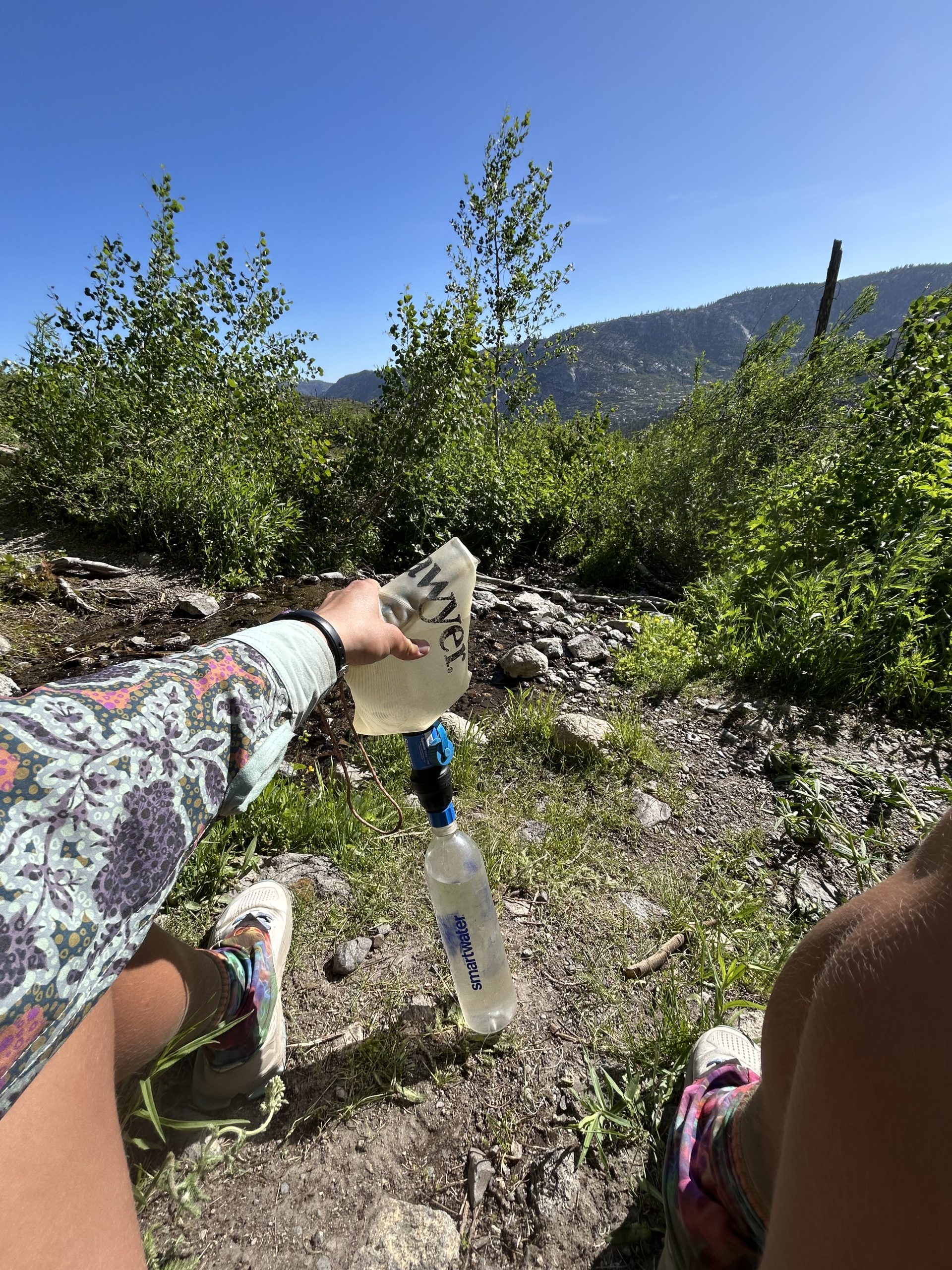
I took a day off to rest my leg and had a telehealth appointment with my physical therapist, Blaze Physio, who has helped me tremendously with issues throughout my hikes. She diagnosed the injury as a quad strain that’s tugging on my knee cap, and showed me how to use KT tape for some structure. After a day off and some new supports in place, I went back to trail with a plan to complete the last 11 miles then continue onto the next section of trail. But after a few miles of hiking, even with a slower pace and the KT tape, the pain only got worse.
Reality Check
A few miles in, hobbling with pain, I sat on a rock in the rain and cried. I felt like a failure. I went into this hike feeling like I could do anything I set my mind to, only to be shot down and told by my body that I simply can’t. For a few minutes I let myself feel this, and let myself grieve the idea of my hike that I now had to let go of. If there’s anything I know about thru-hiking, it’s that it teaches one to be patient and flexible. Plans change constantly and that’s okay. I pulled myself together and came back to the thought that this isn’t the end of the world. It’s a small issue that will take a few days to care for and then I’ll be on my way.
I slowly made my way to the road, got a pick up from an awesome hiker hostel host, and posted up for a few days. Now I am doing some true recovery of my leg, and hoping to get back on trail soon. I’ve met so many awesome hikers coming through the hostel over the last few days, and I’m antsy and excited to get back on trail. I haven’t lost sight of why I’m out here and I think this injury can serve the purpose of keeping me in check. I feel more hungry than ever to be out in the woods, not having to think about anything except walking, eating and sleeping. But for now, rest and recovery.
This website contains affiliate links, which means The Trek may receive a percentage of any product or service you purchase using the links in the articles or advertisements. The buyer pays the same price as they would otherwise, and your purchase helps to support The Trek’s ongoing goal to serve you quality backpacking advice and information. Thanks for your support!
To learn more, please visit the About This Site page.

With beautiful mountain ranges, coastal escapes and vibrant cities, many people choose to vacation in Canada.
The number of tourists and where they are coming from vary from year to year.
But a new survey finds Canada is near the top of the bucket list for U.K. travellers, according to a survey from British trip booking company Travelbag.
“From long-haul escapes to dream destinations, Brits have big travel plans for the year ahead,” Travelbag said in a press release.
Nearly half (46 per cent) of U.K. residents are planning bucket list holidays, the company said.
At the top of the bucket list is Japan, with 32 per cent of those surveyed choosing the popular Asian destination.
“Its appeal lies in its rich history, cultural experiences, and its striking contrast to Western cultures,” Travelbag said in its report. “From ancient tea ceremonies to samurai history, there is much to explore.”
Canada comes in a close second at 31 per cent, with its breathtaking landscapes and outdoor adventures.
“Its vast, unspoiled wilderness, from the peaks of the Rockies to the emerald lakes of Banff, and the showstopping Niagara Falls, makes it an ideal location for nature lovers and adventurers,” Travelbag said.
In third place is Australia (30 per cent), offering once-in-a-lifetime experiences like the Great Barrier Reef and the Gold Coast.
Visitors from the U.K. topped the Statistics Canada May 2025 list of the highest number of overseas visitors. Over 78,000 British residents travelled to Canada in May. Indian residents were second, followed by France and Australia.
A Statistics Canada graph shows the number of overseas visitors by country in May 2025.
See the full report from Travelbag here.
Lead photo of Field, Alberta: James Wheeler
Last 30 Days: 96,569 Votes
All Time: 764,429 Votes
INsauga’s Editorial Standards and Policies
WIN A $100 SHOPPING SPREE!
Subscribe to INsauga – Ontario Headline News’ daily email newsletter for a chance to win a $100 gift card to Toronto Eaton Centre OR Sherway Gardens. Get news delivered straight to your inbox.

It’s early on a Tuesday morning in mid-March, and Isabella Calidonna is ready to run. She’s got a hydration pack wrapped around her back and a smile on her face while standing next to the Baroque Four Rivers Fountain in the heart of Rome, Italy. This centerpiece of the famed Navona Piazza, she tells me, is among more than 2,000 fountains in the city designed by the masterful Italian sculptor and architect Gian Lorenzo Bernini more than 400 years ago.
Calidonna is the founder of ArcheoRunning, a Rome-based running tour company, and she’s leading me on an easy 5-kilometer run that will zigzag through the city’s maze-like alleys. They’re paved with black basalt, referred to as sampietrini in Italian.
The iconic cobblestones date back to the 16th century, when they were first used to cover Saint Peter’s Square in front of Saint Peter’s Basilica, the iconic Italian High Renaissance church in Vatican City. These are the kind of details that Calidonna, who has a Ph.D. in art history and also studied archeology, easily shares mid-stride.
“I work in great beauty,” she says, chuckling. “Rome is very special—full of beauty that has been layered over centuries, from the medieval period to the Renaissance. You can see all that history here.”
Save for local shop owners preparing to open, at 7 A.M. Rome is unusually hushed and absent of tourists, an ideal moment to run through Italy’s most populous city of nearly three million.
“It’s a very particular experience,” Calidonna says of Rome’s pre-breakfast hour ambiance.
From the honeyed rays of sunlight that drench the city’s historic facades, to the quiet and crowdless streets, Calidonna describes this interval of the day as sacred and magical, insisting that it’s worth a wake-up call to encounter this tamer face of the city.
A Run-Tour of the Best of Rome
Calidonna, a six-time marathon finisher, no longer trains to race long distances. But she remains an avid runner. She started coaching in 2016 and logs roughly 20 miles per week as the owner of ArcheoRunning, which she founded in 2019. After constantly encountering tourists studying maps mid-run, Calidonna thought it was a prime opportunity to offer a guided running experience while also bridging her love for art, history, and archeology in her beloved adopted home.
“My running tours are for everyone,” Calidonna says. She adds that she accommodates all paces for the 13 running tours she offers. The company also features seven walking tours.
“I don’t use maps. I am the map!” -Isabella Calidonna, founder of ArcheoRunning
“The Best of Rome” tour is among her most popular. As part of the experience, she brings runners to iconic public squares and famed spots, like the Spanish Steps—the longest and widest staircase in Europe built in the 1720s. The tour also traverses architectural masterpieces, like the Pantheon. The ancient temple, dedicated to the 12 gods of the Roman religion, is one of the best-preserved Roman monuments in the world. A visit to the renowned Baroque Trevi Fountain—dubbed the world’s wishing well, attracting between 10,000 and 12,000 tourists daily—is another highlight of the rendezvous.
One of ArcheoRunning’s more atypical experiences includes taking runners southeast to the city’s “green lungs” to log miles on one of the oldest Roman consular roads. Calidonna describes the area as an open-air museum, where six of the ancient Roman aqueducts—used to transport fresh water for baths, fountains, and drinking to highly populated areas—are preserved. Dating back to 312 B.C.E. and built over a period of roughly 500 years, the Roman aqueduct systems are widely considered to be a masterful and advanced display of engineering.
Beat the Crowds Off the Beaten Path
On this Tuesday morning, I joined Calidonna for ArcheoRunning’s “Hidden Rome” running tour to visit a few of the lesser-known spots in the city. Our first stopping point is the ruins of the Stadium of Domitian, which is located beneath Piazza Navona. A rendered image of the stadium illustrates a horseshoe-shaped arena, which was formerly used for wrestling, foot races, and pentathlons. The space could accommodate 30,000 spectators (still significantly smaller than the better-known Colosseum, which could hold up to 80,000 people, while the Circus Maximus, the largest chariot stadium in ancient Rome, could fill more than 150,000).
I follow Calidonna to Via Coronari, an ancient Roman road in the heart of the city. Formerly referred to as Via Recta, the street was used by pilgrims on the journey to Saint Peter’s Basilica, she explains. These days, it’s full of renovated apartments sandwiched between art galleries and is also a place to hunt for antiques.
As we head to the Ponte district, Calidonna pauses and points at an inconspicuous arcaded lane, Vicolo San Trifone. This, she says, is one of the most distinct streets in the city—the narrowest in Rome, a fact that is often lost on tourists and locals alike. We move on to one of Rome’s oldest markets, Campo de’ Fiori, careful to steer clear of vendors meticulously arranging baskets of fruits and vegetables and buckets of fresh flowers. After we quickly pass by, we continue to a medieval courtyard of Ivy-wrapped ochre houses located through Arco degli Acetari. In the past, the area was used by vinegar makers before it was transformed into accommodations.
As we continue still off the beaten tourist track, Calidonna shepherds me to Passetto del Biscione, a tunnel with a stunning blue frescoed ceiling of cherubs and festoons. In 1796, the passage was reportedly the site of a miracle: an image of the Virgin Mary was allegedly seen moving her eyes, attracting pious Christians from around the city. The passage also served as a corridor to the Theater of Pompey, Rome’s first theater that was dedicated to Pompey the Great, Julius Caesar’s rival.
By the time we reach our second-to-last stop, I can’t help but gaze in awe inside the courtyard of the Palazzo della Sapienza. Here, Calidonna shows me the oldest university in Rome, and the largest in Europe, founded in the 13th century by Pope Boniface VIII. The building, designed by 17th-century architectural genius Francesco Borromini, is a Baroque masterpiece.
As we wrap up the run, Calidonna leads me to the back of the Pantheon. It’s certainly not a hidden gem. Rather, it’s one of the most popular architecture sites in the center of Rome—and the world. This, however, leads to our final stop, the ruins of the Baths of Agrippa. It’s the formerly private bath complex of Agrippa, the Roman general and son-in-law of Augustus, the first emperor of ancient Rome.
I’m still absorbing Calidonna’s granular details as we finish running and arrive at Caffè Sant Eustachio, the oldest coffee roasting company in Rome. The cafe uses water from an ancient aqueduct to make its coffee, like the Americano I sip as I gaze outside, noticing how much Rome has come to life, and it’s only 8 A.M.
A morning with ArcheoRunning feels like stepping into another world, one that serves as an amuse-bouche of the city’s culture, history, and traditions. I’m already ruminating on my return to the Eternal City.
___________________________________________________________
This article was first published by RUN.

*these posts are coming straight from trail, I apologize in advance for typos!*
Location: High Sierra
Start: Mammoth Lakes – 904.4
End: Mammoth Lakes – 904.4
Miles: 0.0
Ascent: 5562 | Descent: 5562
Sleep: Building
What a big day! We woke up around 4am at a beautiful campsite just outside of Yosemite. We wanted to get into the park early and had about an hour drive to the trailhead, so we left the national forest campsite around 5am. We made it to Curry Village inside of Yosemite around 6am and were heading towards the Mist Trailhead around 6:30am.
Back on Saturday we all applied for Half Dome cable permits while eating pizza in Mammoth. We didn’t think we’d get any of the last minute permits issued, but lo and behold Truffles application for 5 permits was approved! This felt like a once in a lifetime opportunity and we knew we had to make it up Half Dome. We had about a mile walk along the road to get us to the trailhead, and once we were on the Mist Trail we started climbing uphill.
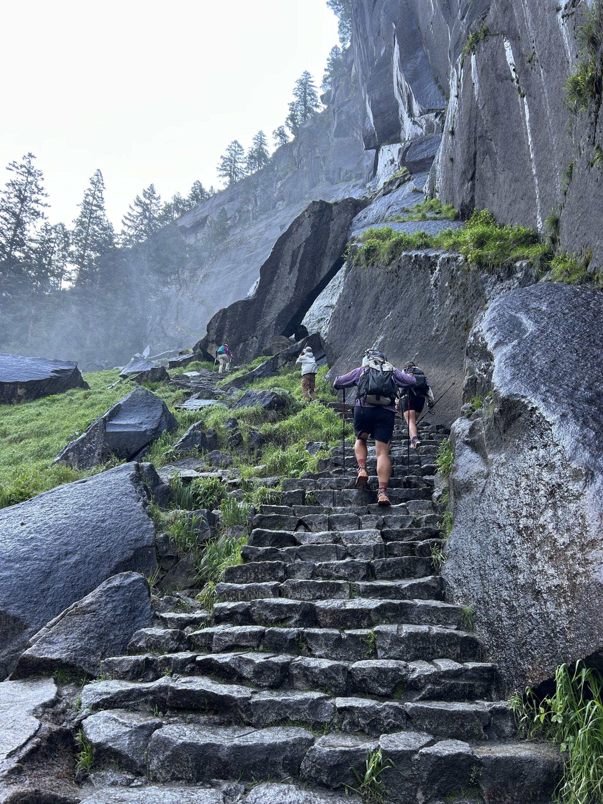
The beginning of the trail was paved and covered with people, even before 7am. Apparently 300 permits are issued for the cables every day, but you don’t need permits to hike up to the waterfalls along the trial and. It’s a hard hike and not for the faint of heart, but I couldn’t believe how many people there were the entire way up! We are in great shape and conditioned for long hikes, but holy shit the hike all the way up was super strenuous and hard! I was shocked by how many “normal people” we saw. Granted we did the trail faster than most of them, but we also had hiked 900 miles up to this point. We had a lot of conversations about day hikers and how impressed we were by the amount of people able to do the trail, it was that hard!
After a few miles we crossed the Vernal Falls Bridge and passed the water station and bathrooms. I couldn’t believe there were full on flush toilets on the mountain, what a luxury! There were lots of signs about how much water you’d need based on what time you were doing. Obviously it was necessary information because of how ill prepared many people were on the trail. I saw lots of flip flops and people that didn’t have water or daypacks or anything…
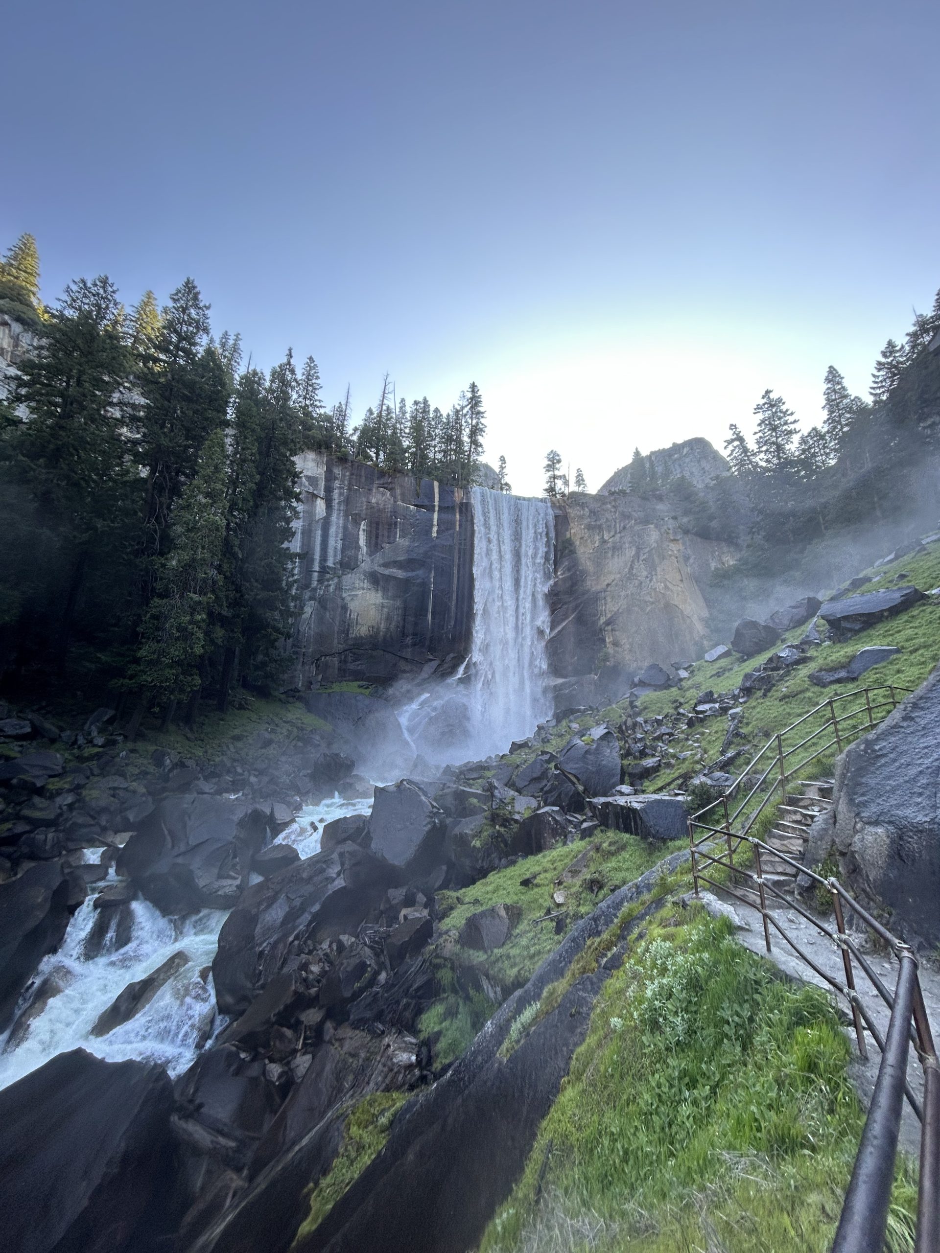
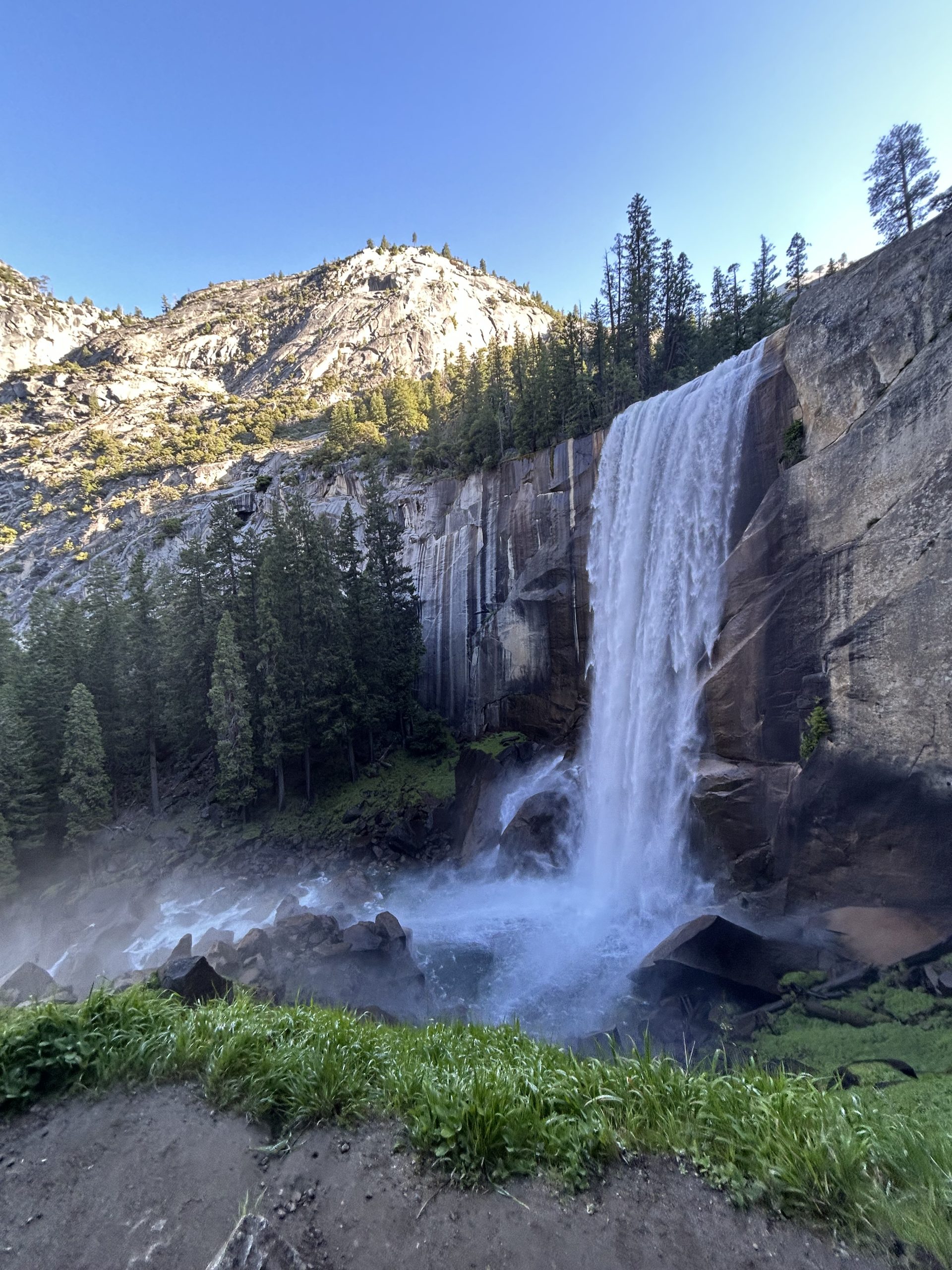
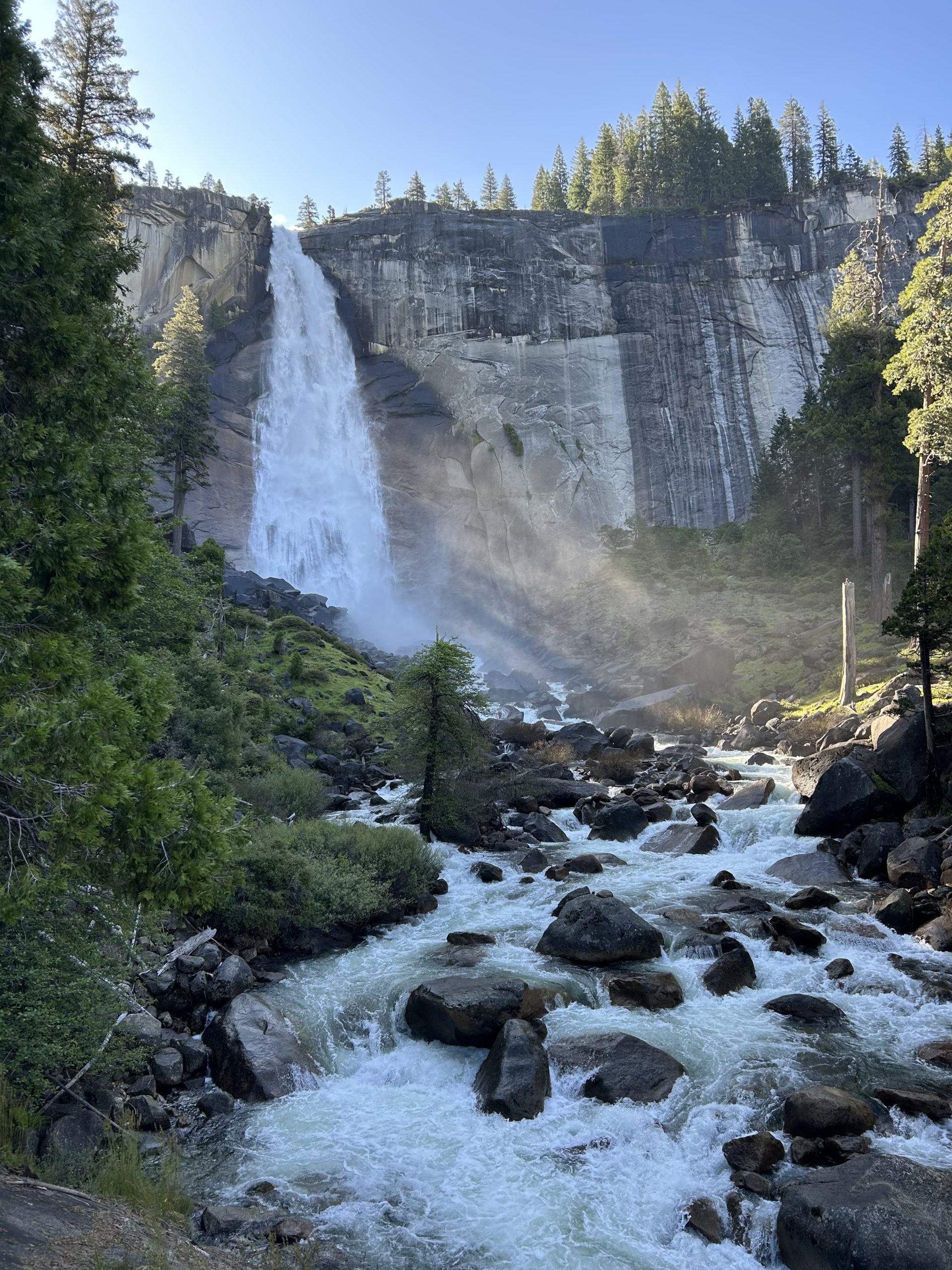
From the bridge we continued climbing up towards Vernal Falls. The water fall was huge and we got super close to it thanks to a ton of stairs. We hiked near the actual falls and ended up on top of the waterfall where the river began its plunge over the cliff. The trail took us past Emerald Pool and continued climbing up towards Nevada Falls. We crossed another bridge and took even more stairs up towards the fall.
After countless stairs and several switchbacks, we were at a junction and yet another bathroom opportunity. This was just a pit toilet, but still what a wonderful reprieve. The trail leveled out significantly for the next several miles and we just cruised along the dirt path. We passed so many people, many of whom were ambitiously heading towards the cables as we were.
When we hit the forest we began to climb yet again. The elevation gain was wild because it felt like we did a ton of climbing in the beginning of the trail, has a break in the middle, and then did a bunch more climbing at the end. We just kept going up and up and up and eventually ended up at the base of the sub dome. There was whiteboard warning hikers not to go up during inclement weather as well as reminding people that permits were required. We didn’t see a ranger and proceeded up towards the sub dome.
This section of the hike was climbing up the granite slab with some cut out stairs and some rock scrambling. I felt comfortable traversing the rock but tried not to spend too much time looking around out of fear that I’d scare myself and freeze. My fear of heights hadn’t been paralyzing yet, but I didn’t want to hinder myself in any way.
When we crested the sub dome it started to get real. The cables were right in front of us and it looked like they went straight up the mountain. The section was about 600 feet long and it looked like people were propelling themselves up the rock face by just hanging onto the cables. I knew that it would be too steep for me to attempt the summit, but my friends were insistent that I at least give it a try.
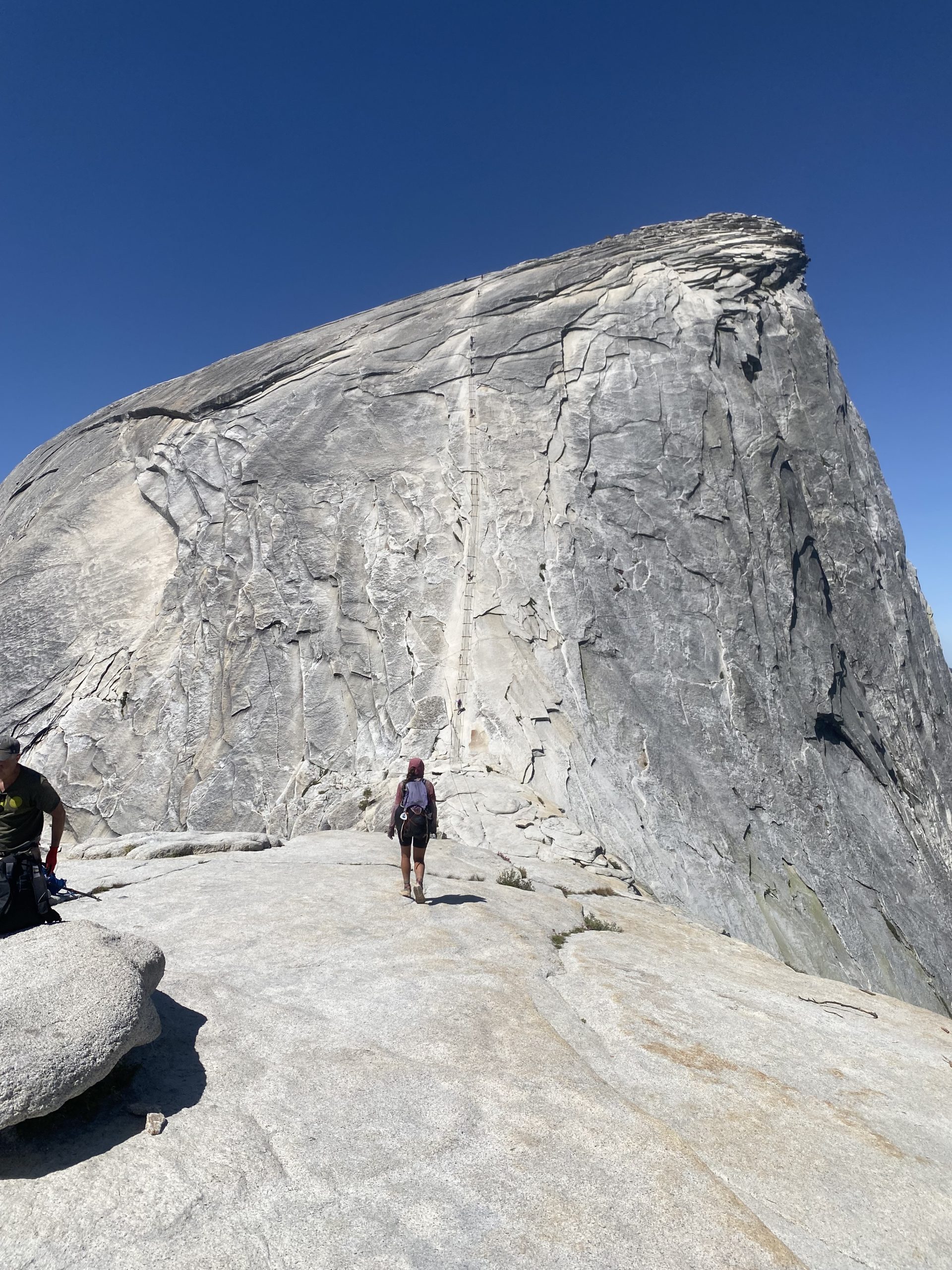
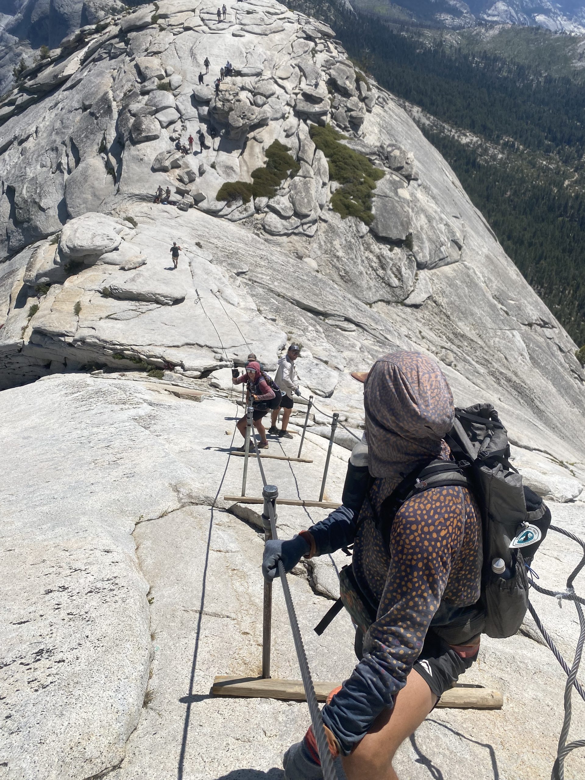
Reluctantly I went to the base of the cables. We all found some gloves that were left by the cables and gratefully put those on. We got into a line and began the slow ascent. I stayed in the back so that it would be easy for me to turn around if I decided I couldn’t do it. I made it maybe 20 feet and got really scared. I started shaking and could feel tears coming on and I told our group I was turning around. They were understandably disappointed and gave me a hard time as I started making my way back down.
I felt so much better when I was on solid ground again. I was disappointed in myself but knew I would have lost my mind if I got even further up and tried to come back down. I found a spot in the shade to sit and wait and ended up having a great time watching the slow progression of people up and down the cables. It took my friends about an hour to get up and down, including the time they hung out on top. Watching them all come down was so nerve wracking because there were so many other people on the cables. There was no order in which people would go up and come down, so people were going in and out of the cables trying to pass one another. It was scary knowing one misstep would be the end of my loved ones. I tried not to focus on that as I watched my friends slowly descending the slab of rock.
Finally they were all safely on the ground. They excitedly told me about their climb and showed me pictures of the view from the top. We sat and hung out for a while watching other people go up and down on the cables before deciding we should go ahead and start the long descent back to the car.
Doing an out and back trail is always fun because I feel like you notice different things going in either direction. It felt like a completely different hike heading down the mountain, there were so many things I didn’t see before. I also didn’t realize how much climbing we did, but I certainly felt it on the way down. I was extra thankful for my trekking poles, especially on all the steep stairs we had to climb down. My knees were feeling it by the end!
It took us about 4 hours to get back to the car. We were all exhausted and limping by the time we finally reached the car. We were also very hungry, so we decided to go back to the visitor center to go to the grill for a snack. We downed some burgers and easily could have eaten more, but we Truffles was adamant he wanted (and deserved chicken wings). We used what little signal we had to look up where a Buffalo Wild Wings was and started driving in that direction.
Civilization was about 2 and a half hours away, but thankfully the drive was pretty and it went by fast. We got to the restaurant around 8pm and it took a long time for us to be seated but we were so tired and hungry it didn’t matter. We devoured the endless wings when we finally got sat and were able to order. We each ate at least 16 wings!
By the time we finished eating we figured it was too late to try and find a campsite. We opted instead to book a cheap hotel room online and were so happy to finally get to the hotel around 11pm. Our $150 room ended up being one of the nicest hotels I’ve stayed at! We were best and fell asleep as soon as we got in the room. What a big day, I’m so thankful to get to end it in a bed! According to Truffles Garmin we did 18.8 miles with 5500’ of elevation change each way. And to think this was technically an “off” day!
Our families flew out to see us in South Lake Tahoe! My parents along with Truffles and Hangman’s mom, plus Pinky’s mom and two younger sisters all made the trip. We rented a large house so we could all stay together and spent several days relaxing and sightseeing. It was the perfect break from hiking and so good to see family!
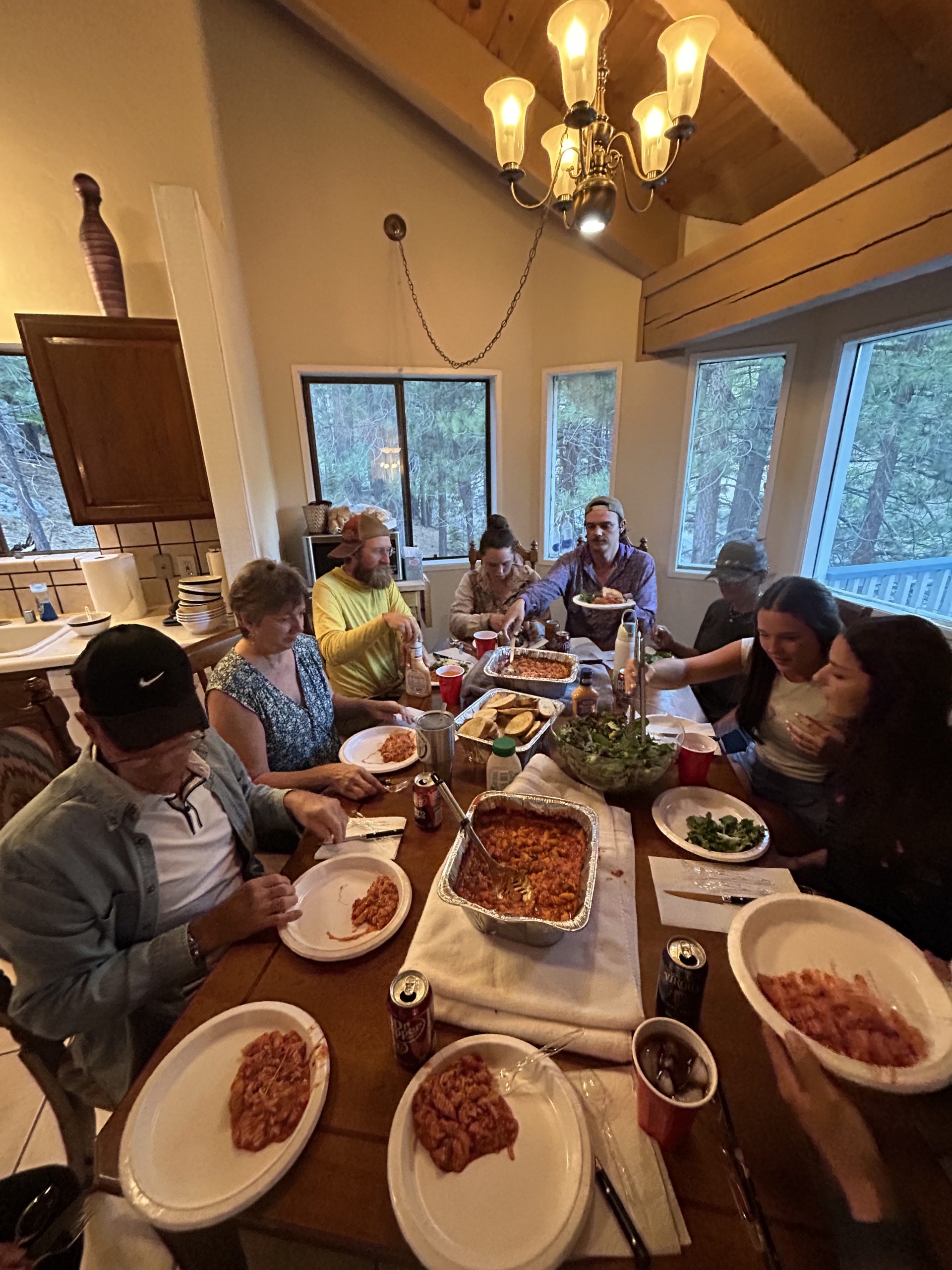
Location: High Sierra
Start: Manmoth Pass – 904.4
End: Red’s Meadow Junction – 907.9
Miles: 3.5
Ascent: 17 | Descent: 1276
Sleep: Tent
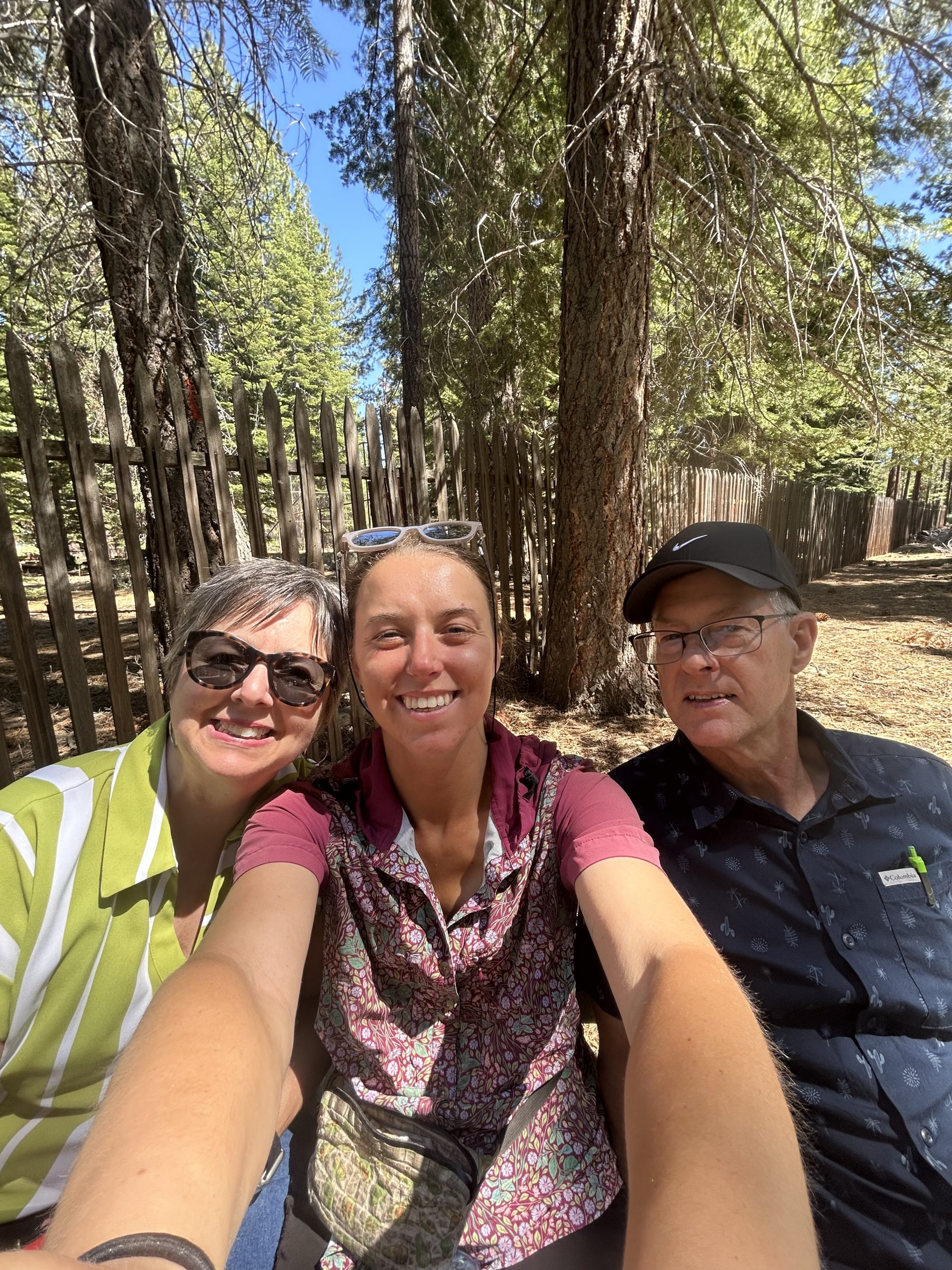
Back on trail after several glorious days off! I was worried I wouldn’t be happy once we were back on trail and that being around our families would make me feel homesick, but today was a great day and I felt very thankful to be out here.
Our families had morning flights out of Reno, so they all had to leave by 7:30am. I got up around 6:30am so k could drink coffee and spend time with my parents before they left. My parents are heading to Yellowstone after our visit to do some sightseeing of their own, so we talked about their trip and what they were excited about. It was sad to say goodbye to Hangman and Pinky, it doesn’t feel right being on trail without them. I think Hangman made the right call by choosing to go home and heal rather than trying to stay out here in hostels or hotels. It sucks that they have to go home and I know it will be hard to get back on trail, but he needs the time and space to heal. We are bummed and I know they are as well, but we’ll see them again in a few weeks!
Our families got out the door on time with lots of hugs and kisses goodbye. That just left Pimento, Truffles, and I. We hung out at the rental house for a few extra house taking our time with breakfast and packing up. We soaked up all the internet connectivity we could and were out there door around 10:30am.
It was just under a 3 hour drive from South Lake Tahoe to Mammoth Lakes. We made good time and only stoped along the way for bathroom breaks and to get a “real milkshake” (that ended up being delicious and was absolutely worth the stop). We got to the Horseshoe Lake trailhead to Mammoth Pass around 2pm. Pimento is planning to get back on trail tomorrow where he got off in Bishop, so he dropped us off and then was going to drive the rental car back down to Bishop. He’ll be about 2 weeks behind us but is planning to skip up to where we are when Pinky and Hangman return.
We said our goodbyes to Pimento and were hiking up the trail just after 2pm. We had about 3.5 miles back up to the PCT and then were going to find a campsite somewhere after that. I set out ahead and Truffles but figured he’d catch me soon. I stopped to wait at one point and when he didn’t show up after 15 minutes I started asking day hikers if they’d seen a solo guy in a blue shirt and big backpack. When no one had I got worried and decided to hike back down to the parking lot.
Truffles was no where in site and I frantically called him. I didn’t expect him to have signal but thank goodness he did and he picked up. Apparently he had taken an alternate trail to McLeod Lake and was waiting for me there. I was aggravated but he was apologetic when I finally found him. Now that it’s just the two of us out here I really want us to stay together and I felt panicked that we wouldn’t have any way to reach one another if we were separated. We were reunited at the lake and continued to hike on together.
The trail back to the PCT wasn’t nearly as bad as I remembered it being. I had been dreading the hike up, but it ended up being pretty mellow with very mild uphills and a good amount of downhill. We were back on the PCT before 4pm and decided to head towards the junction to Red’s Meadow. Truffles had to dig a cat hole but we made plans to meet and get water near the junction.
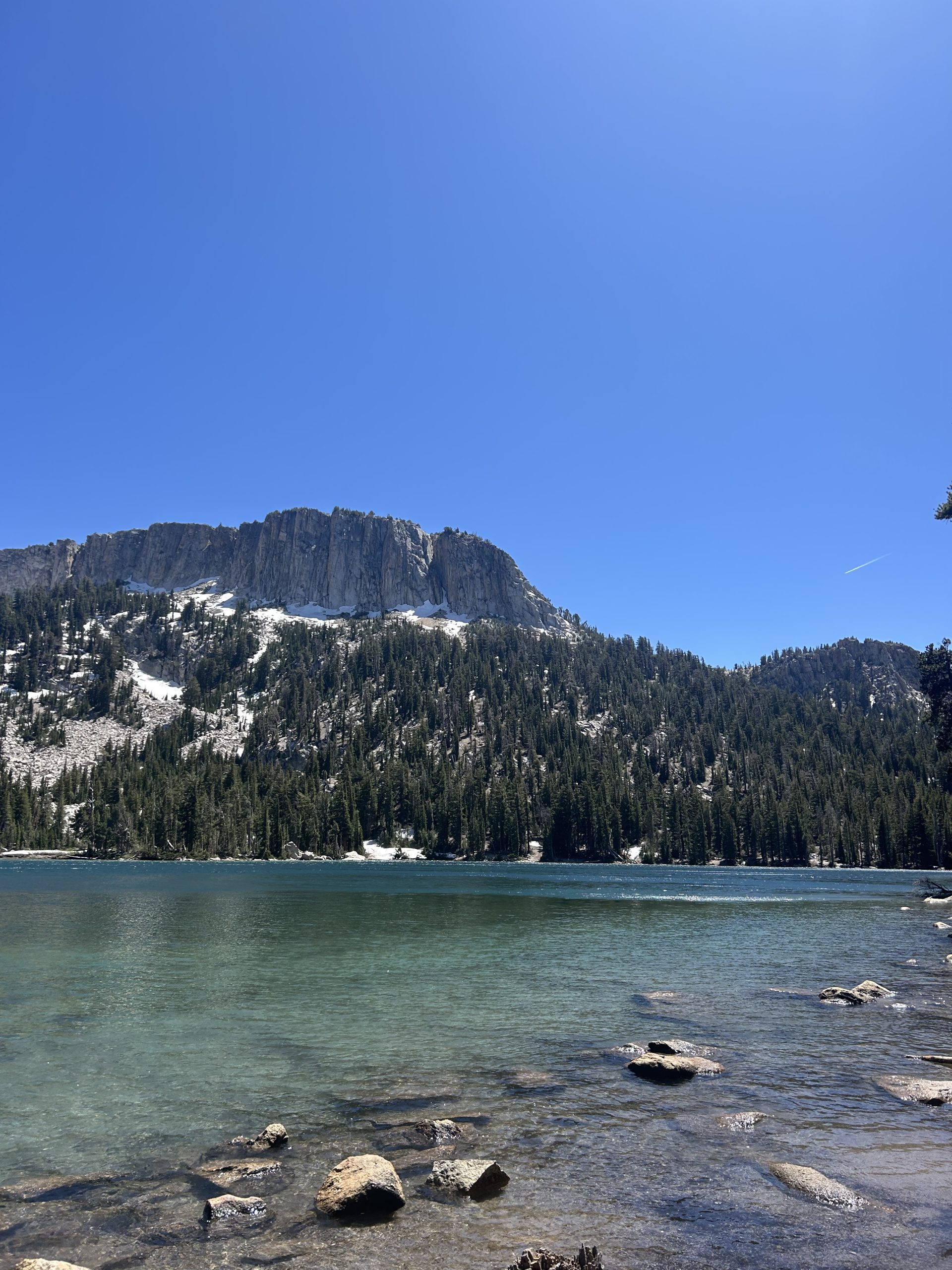
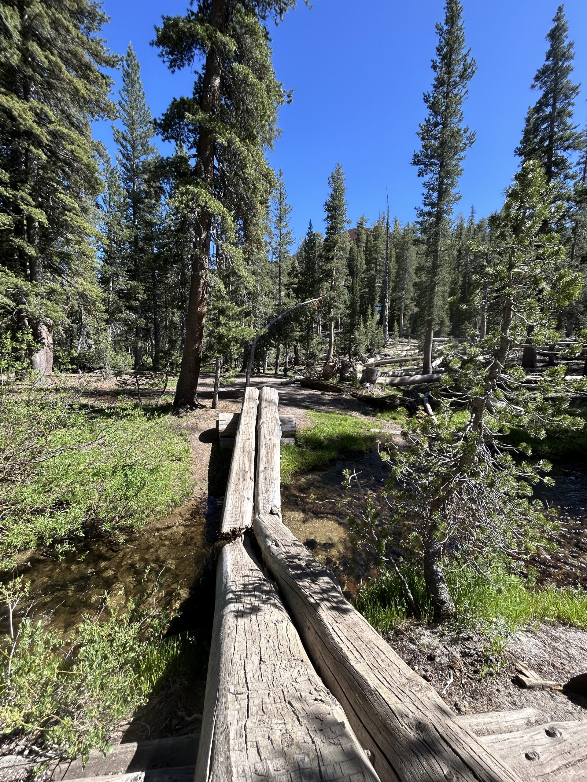
The trail this afternoon was beautiful! I hiked through tall pine forests and over multiple babbling brooks. There were areas that were sunny and exposed, but for the most part things look really green and lush (especially around the water). I didn’t hike through any snow today, I guess summer is in full force and the snow melt has made way for greenery. I paused at several of the water sources to admire the moss and flowers, it reminded me of home. The big difference was the huge snow capped mountains in the distance.
I stopped at our planned water source to filter water for the evening. Since we weren’t sure where we would camp was wanted to be sure we’d have water in case we chose a dry campsite. Truffles caught up and decided to go a little further. We met back up at the junction and continued on together for a bit before seeing some nice campsites down off the trail. Unfortunately it was a dry campsite but we had plenty of water to get us through the evening and tomorrow morning.
We set up the tent and were thankful the mosquitos weren’t out before of how windy it was. In the sunshine the wind was okay, but I know it will be chilly when the sun goes down. We made dinner and talked about our family’s visit and about how crazy it is to just be the two of us. Today is our two year wedding anniversary so we talked about all the adventures we’re had together the past couple of years.
We’re both worn out after our time away from trail, so we got in the tent early. Again the wind is chilly so we were happy to snuggle up in our sleeping backs. I think we’ll enter Yosemite tomorrow! We did 7 total miles today: 3.5 back to the PCT and 3.5 nobo on the PCT. A nice little re-entry after not hiking for a few days.
-

 Brand Stories1 week ago
Bloom Hotels: A Modern Vision of Hospitality Redefining Travel
-

 Brand Stories3 days ago
CheQin.ai sets a new standard for hotel booking with its AI capabilities: empowering travellers to bargain, choose the best, and book with clarity.
-

 Destinations & Things To Do1 week ago
Untouched Destinations: Stunning Hidden Gems You Must Visit
-

 AI in Travel1 week ago
AI Travel Revolution: Must-Have Guide to the Best Experience
-

 Brand Stories3 weeks ago
Voice AI Startup ElevenLabs Plans to Add Hubs Around the World
-

 Brand Stories2 weeks ago
How Elon Musk’s rogue Grok chatbot became a cautionary AI tale
-

 Destinations & Things To Do2 days ago
This Hidden Beach in India Glows at Night-But Only in One Secret Season
-

 Asia Travel Pulse3 weeks ago
Looking For Adventure In Asia? Here Are 7 Epic Destinations You Need To Experience At Least Once – Zee News
-

 AI in Travel3 weeks ago
‘Will AI take my job?’ A trip to a Beijing fortune-telling bar to see what lies ahead | China
-

 Brand Stories3 weeks ago
ChatGPT — the last of the great romantics
You must be logged in to post a comment Login