
Published August 8, 2025 03:00AM
Destinations & Things To Do
The Laugavegur Trail | Day 4 | The Ending No One Would Imagine
I woke to the sound of glacial runoff just outside my tent. The sky was gray, the wind steady, and the air in the upper 40s—no rain, just the kind of morning that felt purely Iceland. I moved slowly, not from pain, but to hold onto every moment.
It was the last day on the Laugavegur Trail. I missed dry shoes and hot showers, but I wasn’t ready to let go of the rhythm of walking, breathing, and becoming.
Now, take meds, apply the “blue magic,” make breakfast, organize gear, hit the bathroom,get water, pack up and hike.
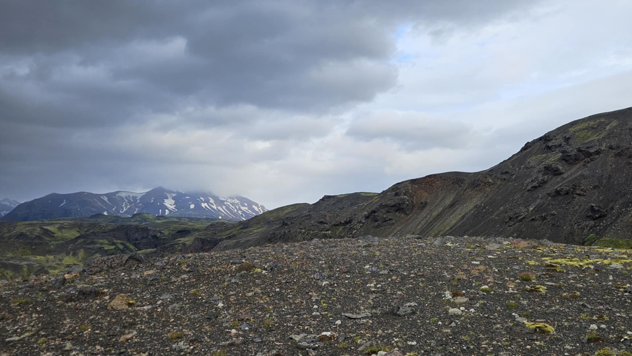
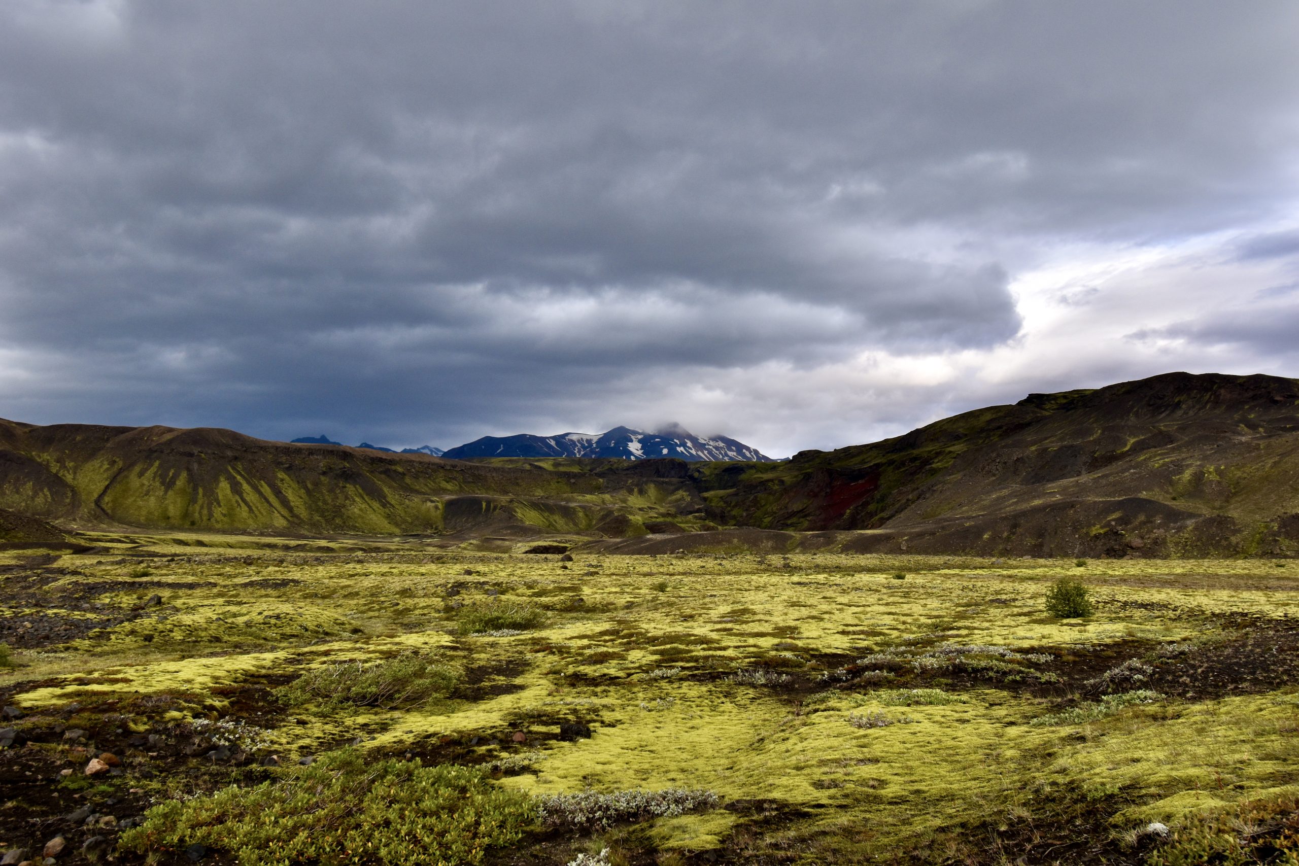
Into the Ridges
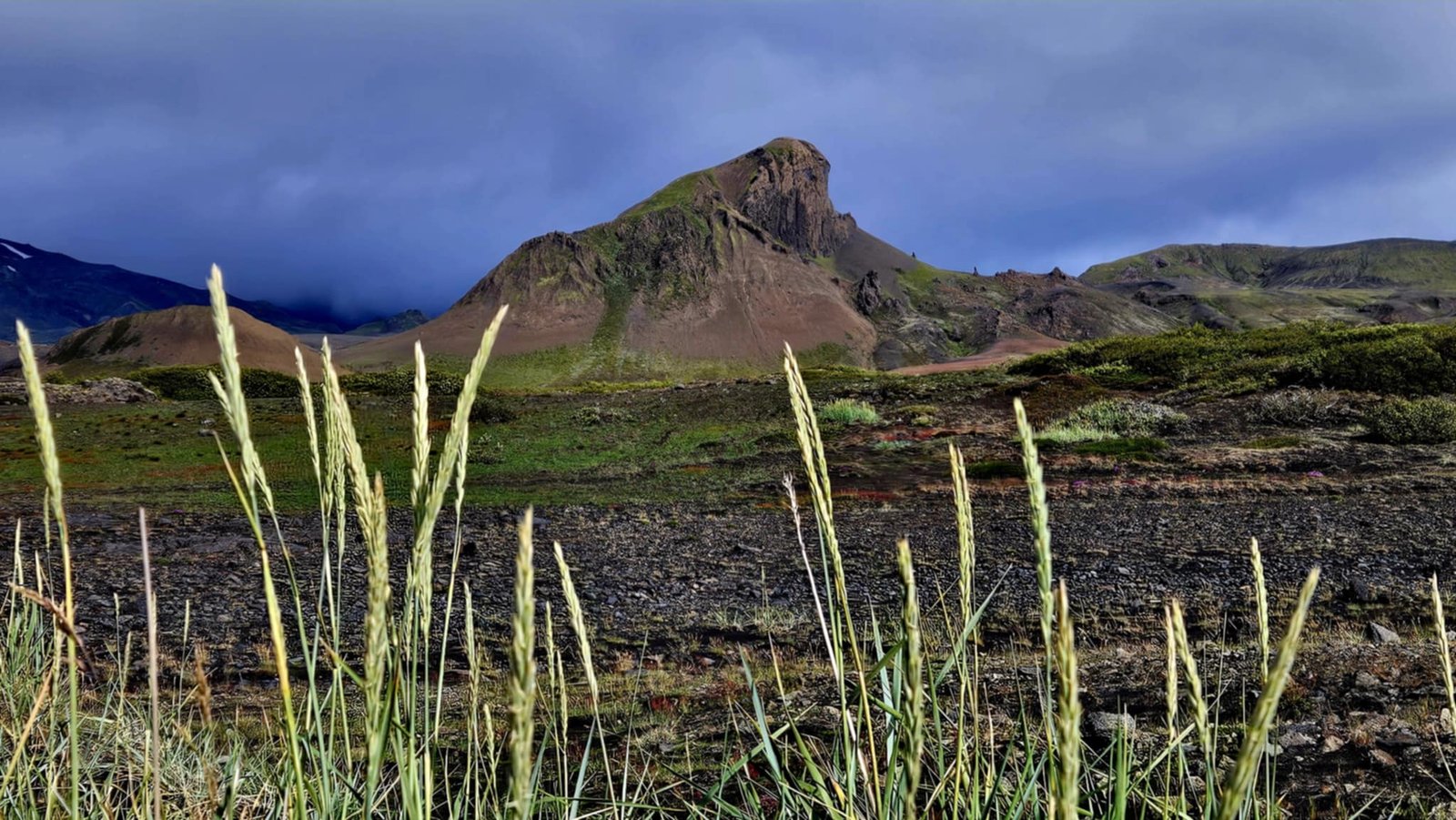
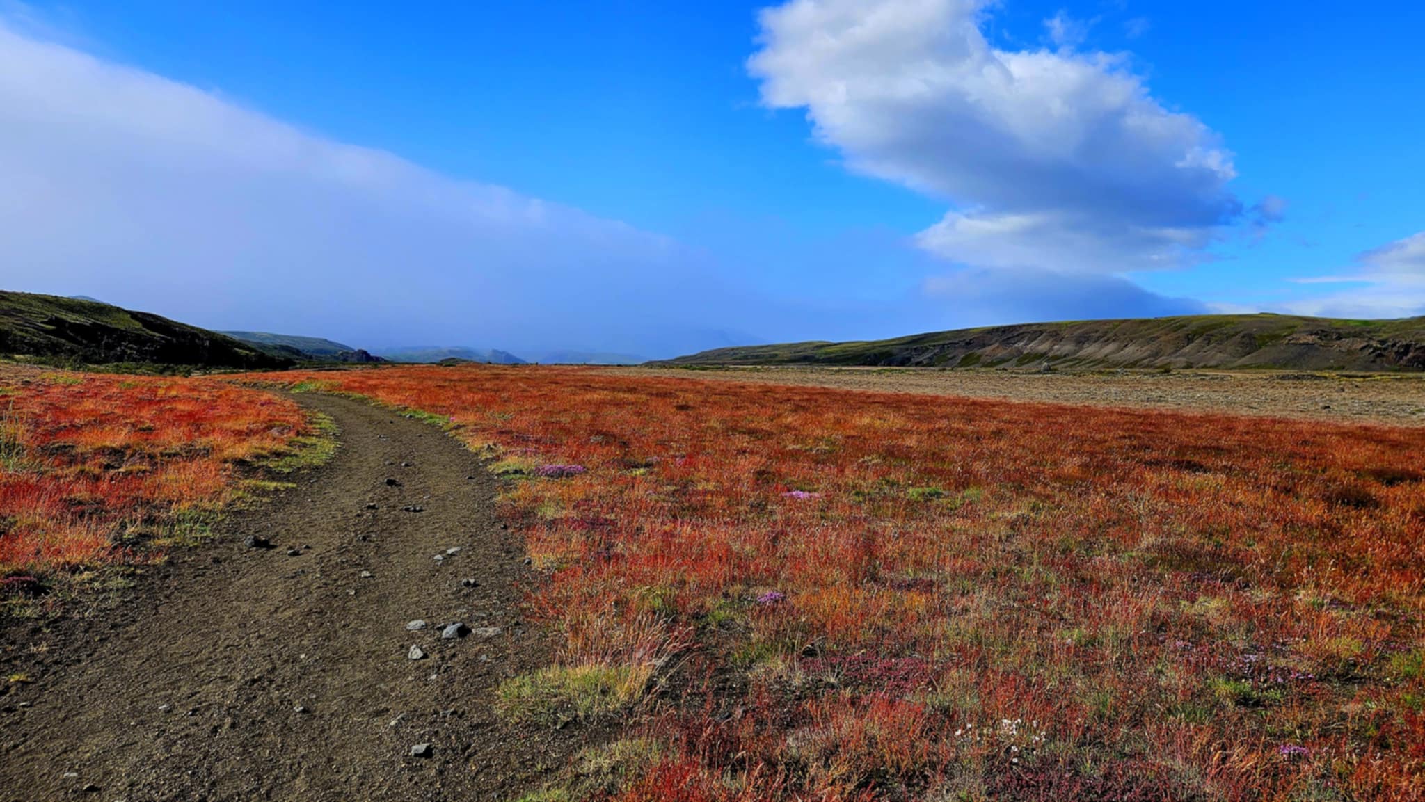
The day started with a series of climbs—big and small ones. After crossing the first ridge, I dropped into a glacier-carved valley, only to climb right back out. Then came another ridge, where the world turned surreal. Greens and blacks painted the land like an oil pastel drawing under a sky with no sun. Somehow, the lack of light made everything more vivid, as if the landscape were lit from the inside out.
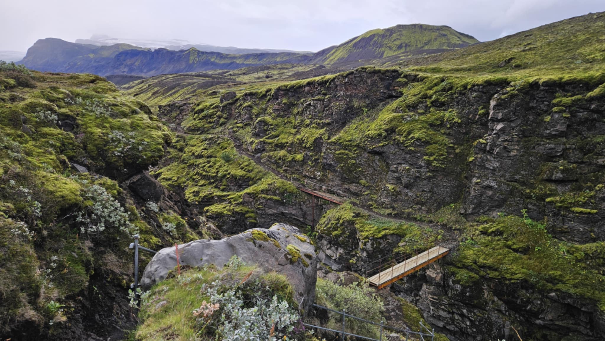
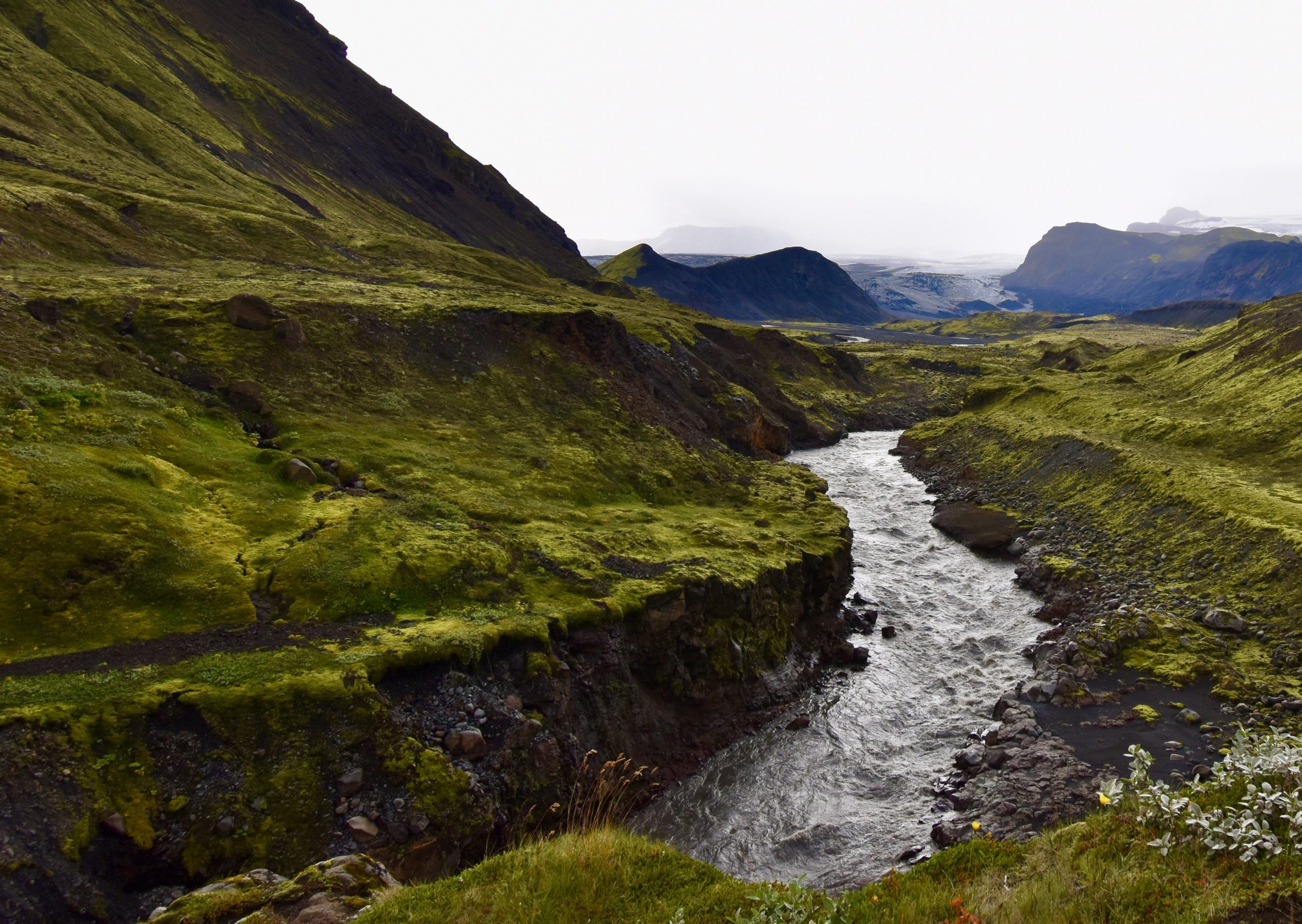
Soon, I descended steeply into another valley—no switchbacks, just loose rocks and black sand. At the bottom, a glacial river roared, wide and fast. There was a bridge that led me across the raging waters onto a trail that was only for the brave. An iron chain to the right and a 75 foot drop to the left.
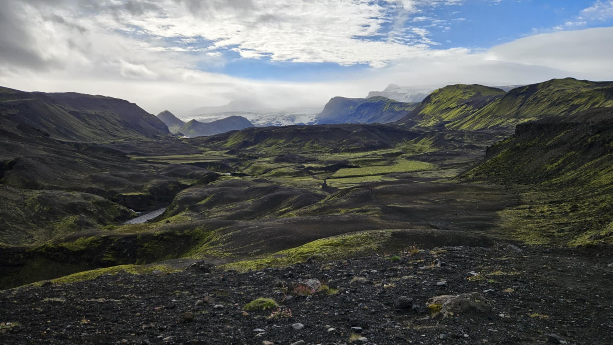
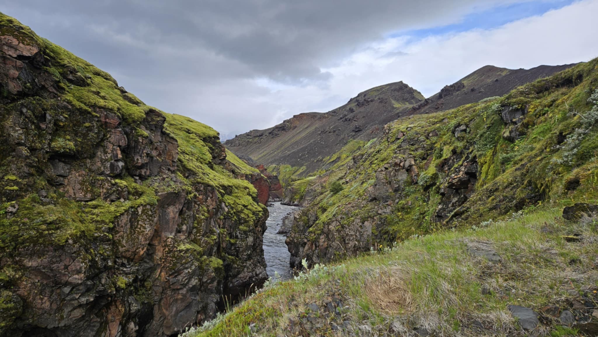
Then the Beauty Broke Me
Eventually, the trail opened again. The cliffs gave way to glacier-capped ridges, velvet-green hills, and skies that stretched out in every direction.
And yet, I had no words left. Every twist in the trail revealed a new masterpiece: surreal colors, jagged ice, and a silence.
When I finally reached the top of one ridge, I flung my arms wide and yelled—not from exhaustion, but from pure joy. I had done it. Almost.
“I will finish,” I told myself. This was my very first thru-hike. I had earned every inch.
6.3 Miles to Go: The Ugly Cry
As I passed the 10K marker—just 6.3 miles to the finish—I began rehearsing a video I wanted to record for my children at the end of this journey.
“Hi Braelyn and Brevin, I love you”
But before I could finish, I broke.
The tears came like a flood.
I missed them. Then my mind shifted to he pain of the past: the divorce, the move, the grief. I saw my Daughter’s face the day I told her I was leaving. Her heartbreak still echoed inside me.
Clearly, I hadn’t let it go.
So I cried—loud, ugly, and raw.
The trail wasn’t just about hiking. It was healing.
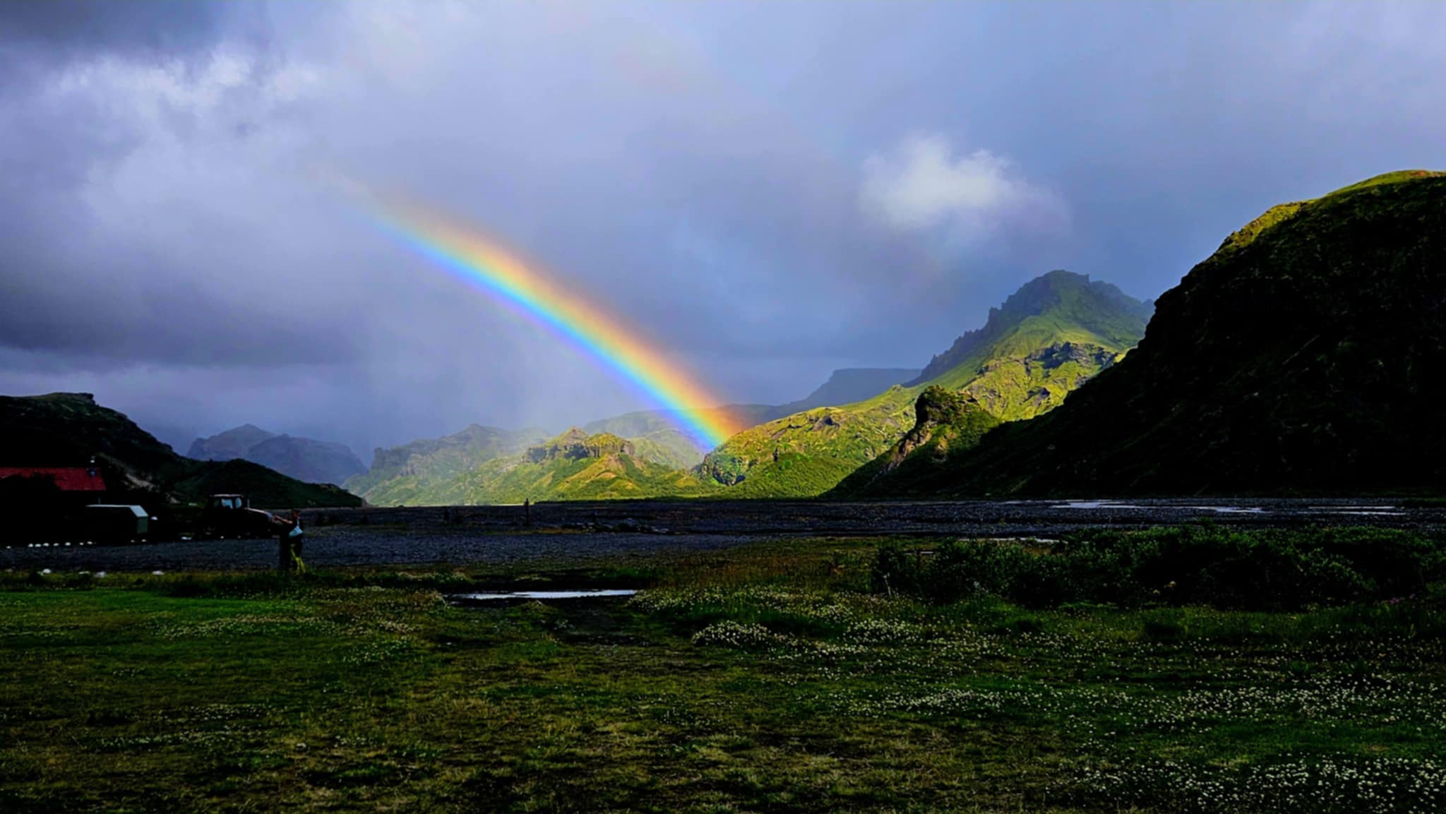
5 Miles Left: The Sun Breaks Through
Just five miles remained.
As soon as I caught a signal, I messaged everyone who mattered:
“5 miles left. I’m going to finish!”
Right after I hit send, the clouds parted. Sunlight spilled across the trail, warming my face like the universe had just offered a high-five.
Of course, my blood sugar crashed at this point, so I paused to eat two of my three remaining glucose tabs. While resting, I spotted two familiar faces from Day 2—Haco and Nate from California. Just like that, trail magic returned.
Then, as if the trail were orchestrating a reunion, Josh and Kelly appeared. We had joked online about finding each other out here. And now, we had.
In that instant, I knew: I would make it.
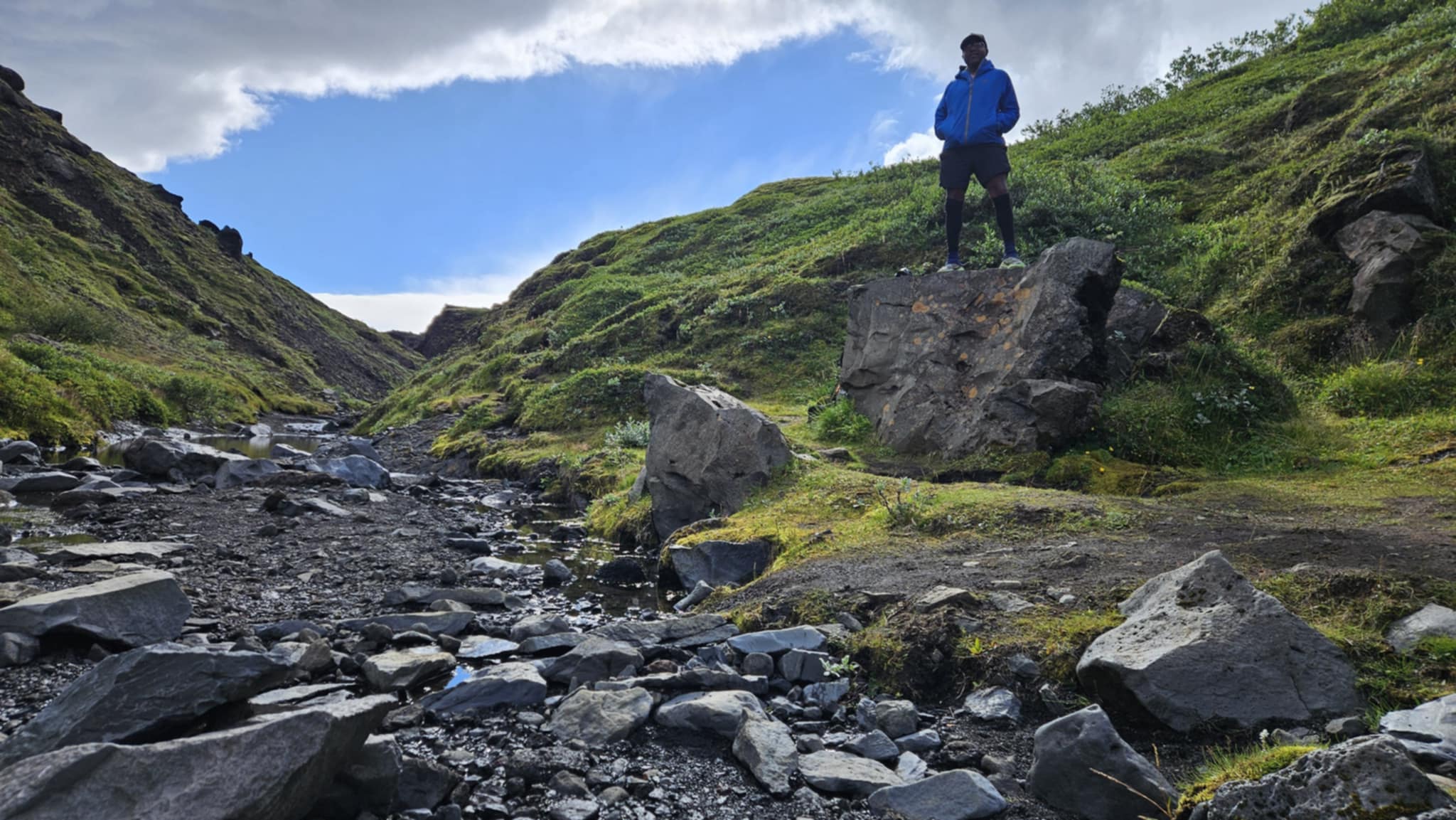
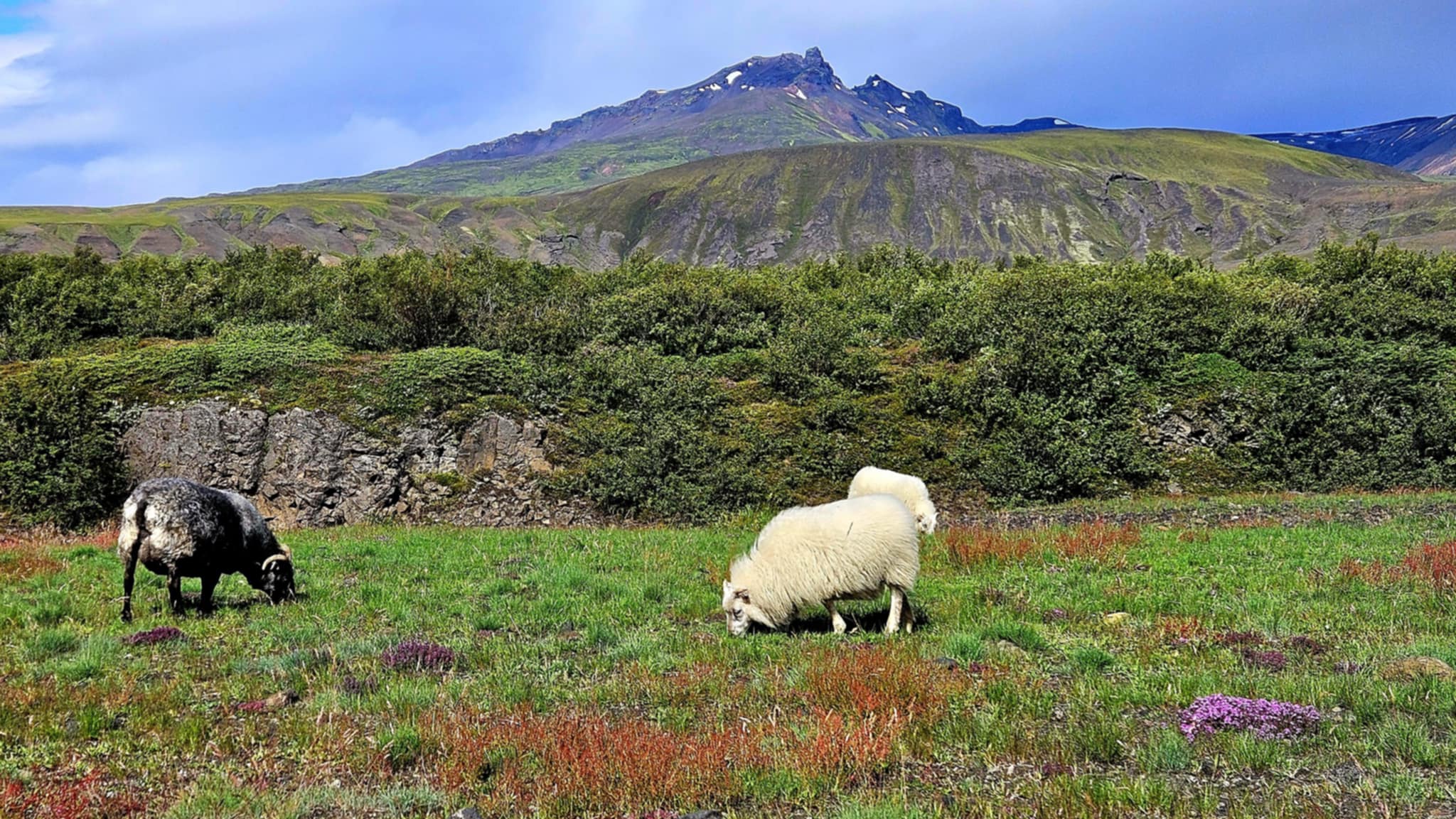
2.5 Miles Left: Sheep!
Soon, the landscape softened. Grass spread wide. Lava rocks dotted the terrain. Sheep grazed without a care. And—finally—trees appeared.
However, the peace didn’t last.
Next came a gorge, followed by a steep ridge. And then, the air changed. Something was coming.
I climbed, and at the top of the ridge I saw it—a wall of clouds. They weren’t moving. They were waiting.
2.3 Miles: Man vs Nature
Iceland’s geography is nothing if not unpredictable. Storms here don’t simply pass—they can hover, caught between colliding wind currents, waiting for just the right moment. This one had clearly waited for me.
Suddenly, a wall of wind slammed into me from the left. My hat flew back. My pack cover ballooned like a sail. In an instant, I wasn’t hiking anymore—I was fighting. Man versus nature.
I dropped to the ground. Gravel tore into my knees as I crawled toward the only shelter in sight—a single rock. Sand whipped across my face as I curled behind it, pressing my cheek to the ground. The wind shrieked like something alive. My mouth filled with grit. My eyes burned. The trail that had empowered me all week now felt like it wanted me gone.
For a moment, I honestly believed I couldn’t go on. But then, I started singing a Cherokee song for protection from my ancestors. Gradually, the wind eased—just enough for me to move.
2.3 Miles (Part 2): The Warrior Within
Shaking, I stood. Then something cracked wide open inside of me.
“That’s all you got?!” I shouted into the clouds, arms flung wide like some unhinged Norse warrior. “I’m going across this ridge whether you like it or not!” Then came a tribal yell—loud, defiant, primal.
It was ridiculous. It was dramatic. But it worked.
Well… almost.
As I swung my pack back on, another gust struck—hard—like a punch from Njord himself. The weight and wind combo knocked me flat. Standing was no longer an option. So I bear-crawled with a pack loosely dangling from my body, back down the trail until I reached calmer air. Only then could I strap it back on properly. I was scraped up, windburned, and rattled—but not broken.
I still had a fight left in me.
2.3 Miles (Finale): The French Couple
Just when I thought I was alone, I saw them.
Two figures walking straight towards me—calm, steady. A French couple. No words exchanged. Just a nod.
And I followed.
Because with them, the fear shrank. Even though the wind still screamed, I wasn’t alone anymore.
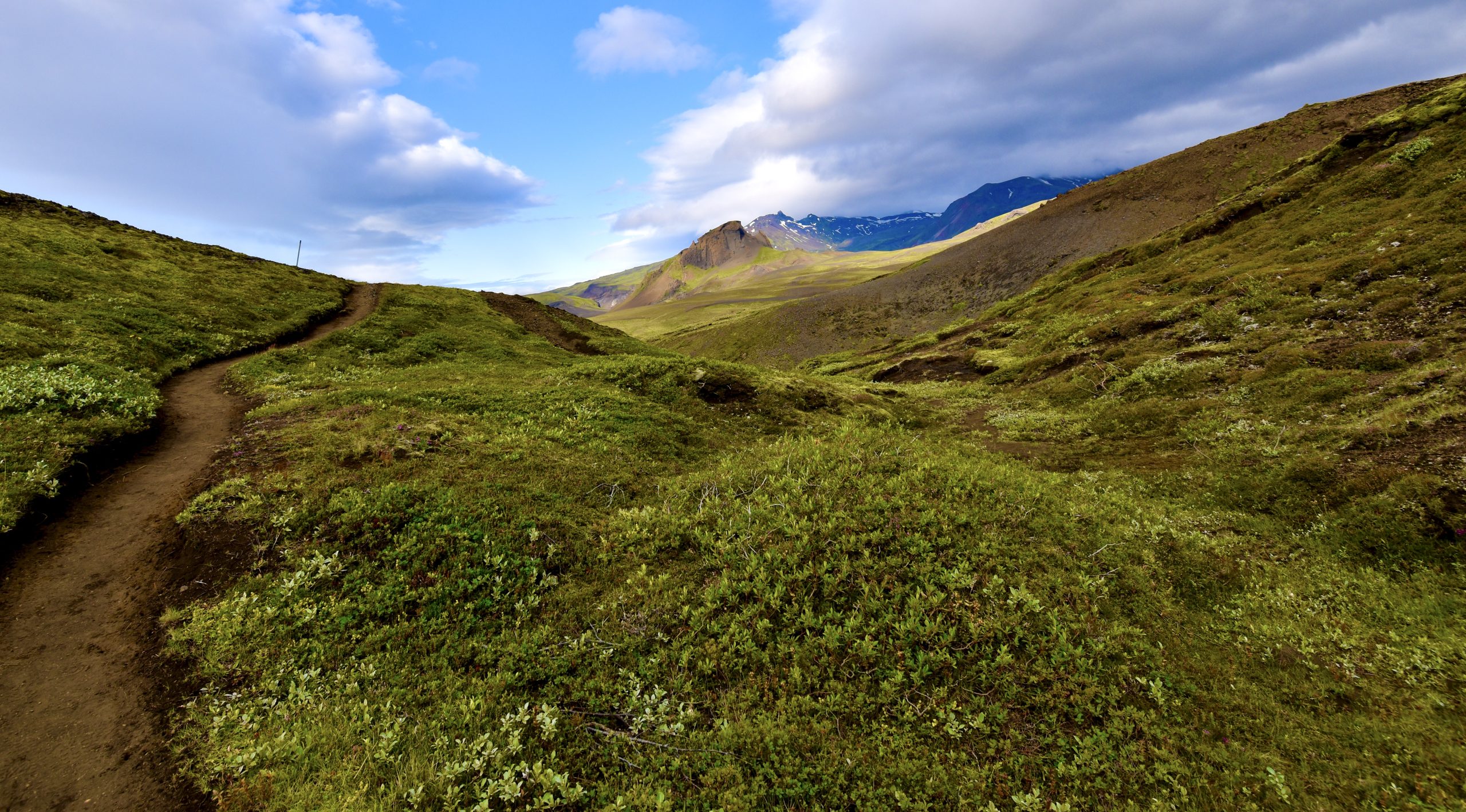
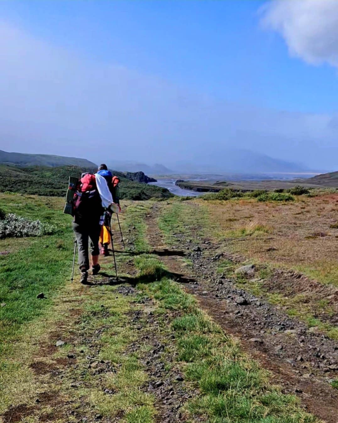
1.5 Miles Left: Keep Going
Eventually, I reached one last obstacle—an icy, wide river. My camp shoes were destroyed, so I crossed barefoot. The water stabbed. But I didn’t fall. I didn’t stop.
Then, Thórsmörk appeared like a dream. Families laughed. The world felt normal again.Yet inside me, everything had changed.
I thought of every training run, every fuel packed meal, every plank and shakedown hike.Without a doubt—it had all been worth it.
1 Mile to Go: Quiet Survival
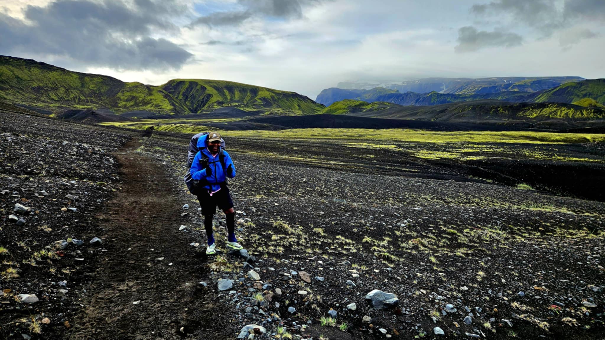
By the final stretch, my blood sugar had dropped dangerously low. I was completely out of snacks, with only one glucose tablet left. Two meals remained in my pack, but neither could help me now. My brain felt foggy. My legs barely responded. My body wobbled beneath me—unsteady, hollow, and weak.
I didn’t finish this hike on a high note. I finished in the middle of a quiet, invisible battle—one I fight every day. Diabetes doesn’t care how much you’ve trained or how prepared you think you are. I hadn’t accounted for how constant movement would accelerate my metabolism. I didn’t factor in the physical toll a windstorm would take on my body. By the time I realized it, I was already too far in.
The End: Survival Over Celebration
From there, my memories come in pieces. I remember climbing a set of stairs and passing a family that smelled like fresh Ivory soap. I heard someone say they couldn’t wait to get to the restaurant. I saw a hut and tents, and maybe even familiar faces—but the fog in my head was too thick to make sense of anything.
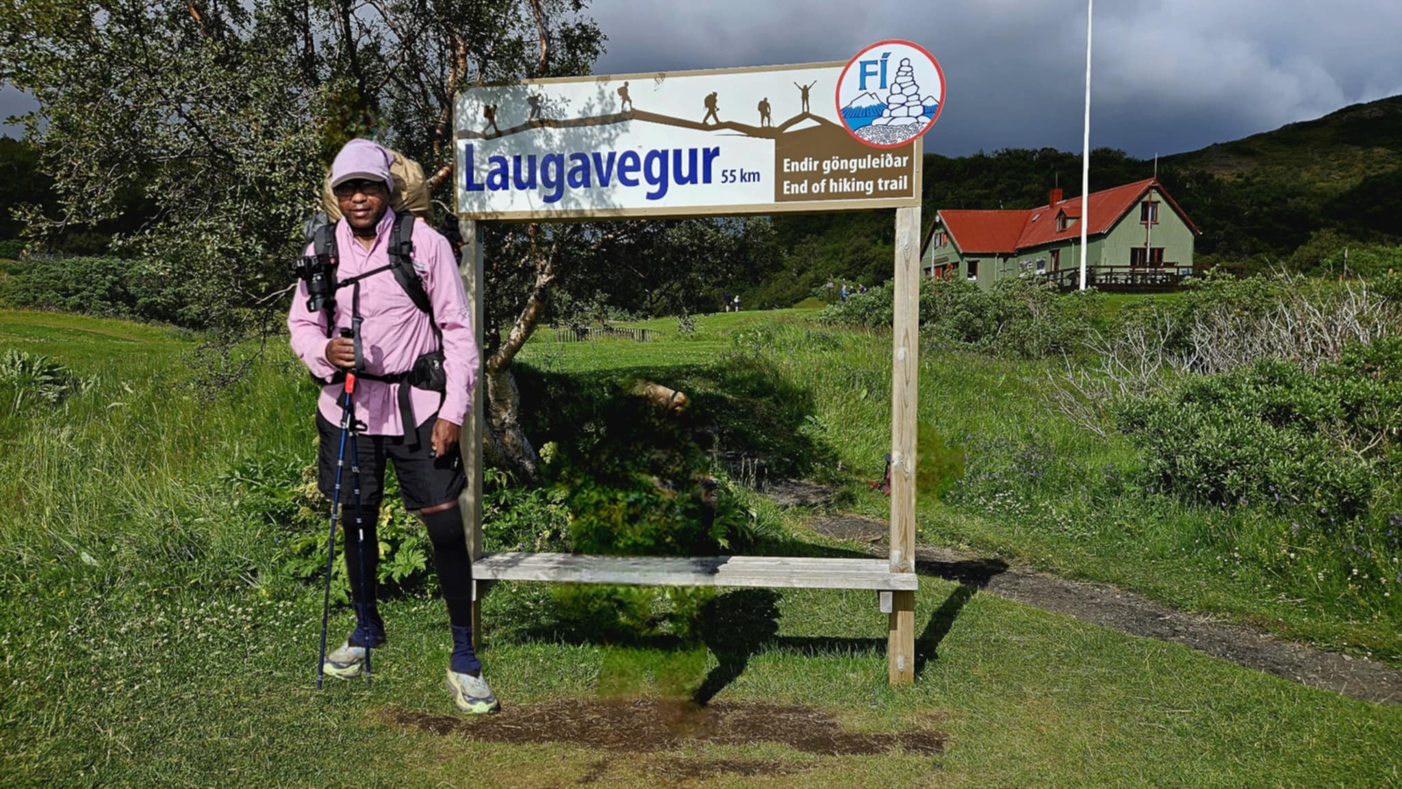
Suddenly, I was at the sign marking the trail’s end, asking someone to take my photo. I couldn’t stand straight. I tried to smile, but my body slumped. The photo turned out awful.
The version you see?
I created it on my phone.
When I finally made it to my bunk, I collapsed. Hands shaking, I tore open my last lunch and ate without tasting it. Then I just… sat. Staring at the wall. My face was numb, my lips tingling and my ears were ringing. I could hear voices around me, but none of it registered. I was there, but not really.
This wasn’t the triumphant ending I had imagined. There were no victory arms in the air. No tears of joy. No laughter or smiles. Just the quiet reality of survival. Of getting it done. Of giving everything I had—body, mind, and spirit.
I completed the Laugavegur Trail at approximately 2:00 p.m. (GMT) on Thursday, July 24, 2025.
Final Reflection: This Was More Than a Hike
Now it’s 9:48 p.m., and I’m sitting still. My body is destroyed, but my heart is full.
I need to honor the people I met—because they weren’t just fellow hikers. They were part of my story.
There was the Icelandic guide who survived an avalanche. Gloria from Italy, who spoke about trails like a fortune-teller. The Pennsylvania tribe—Barbara, Shirley, Laurie, Stacey, Tanya, Sherry, and Tracy—who felt like family.
Then came the San Diego solo hiker reconnecting with her mother’s roots. Gus and Jon from Belgium, hiking 300 miles because of a drunken night. The Hungarian hiker who let me charge my phone so I could call my kids. A Czech couple. A Danish family.
Brad and Caitlyn, who helped me on Day 2. Kiel, only 22, fearless and free—exactly who I want to become. Josh and Kelly from Arizona, who turned tea into friendship.
And finally, Katya and Todd. Lifers.
When I hugged them goodbye, I knew: this was rare.
Because this wasn’t just a hike.
It was a declaration—of who I am.
And tomorrow, I’ll still be a backpacker.
Continue Reading
Destinations & Things To Do
Top Three Challenging Travel Destinations of 2025: Paris, Hanoi, and Shanghai
Published on
August 8, 2025 |
By: TTW News Desk
According to a study conducted by Ibiza Summer Villas, Paris has earned the dubious title of the most stressful city for travelers in 2025. Paris is one of the world’s most iconic cities, and a prime tourist destination. However, the ever-increasing waves of tourists, soaring crime, and weather conditions are straining an already overburdened infrastructure. Paris is estimated to receive around 47.5 million tourists every year, packed in an area of 105 sq. kms. This geographical crunch has been a significant factor to the stress faced by tourists. Curently the number of tourists to Paris is 47.5 million.
The Struggles of Paris: The Impact of Overcrowding
Tourism has become a challenge for Paris, the City of Light, in multiple aspects. As descending loads of visitors gather, the tourists get stressed out trying to get to important places like the Eiffel Tower, the Louvre, or Notre Dame. Paris has to deal with greater congestion year after year, which leads to ridiculously long wait times, a lack of breathing room in public spaces, and in some cases, difficulty traversing the main attractions of the city.
Out of all the places in Paris, its cultural and historical embrace ease it’s rounded out with the downright awful ranking in public safety, sitting twenty-five places away at the fifth worst. The rise of crime in Paris has become a worrying trend, particularly when it comes to the constant threat of pickpockets in heavily trafficked tourist areas.
Hanoi: A City of High Humidity and High Stress
Following Paris, Hanoi is projected to be the second most stressful city to travel to in Vietnam in 2025. With an almost 84% humidity, the city’s weather is often regarded as an uncomfortable challenge for many travelers and a potential deal breaker. The capital’s temperature in conjunction with its humidity often gives an impression of an overexposed sauna. Visitors wishing to venture more into Vietnam’s history, culture and delicious street food find Paris’s captivating charm hard to resist.
Increased tourism and inadequate city infrastructure to support the modern services and amenities required by an international city is its major of concern. The traffic, narrowing pavements, street air quality, and general congestion posed a serious obstruction for the travelers navigating around the city. Along with the markets and monuments, tourists can gather and admire the much needed culture in Hanoi. The capital’s entertaining yet physically taxing ambiance is certainly displeasing to a traveler looking for tranquility.
Shanghai: Overcrowding and Negative Reviews
Shanghai stands as China’s economic power ring, sitting at third position on the list. Indeed, the region portrays an exquisite skyline, and boasts as one of the global centers of finance, but Shanghai has its flaws. Over 300 million tourists flock to Shanghai every year, making it a household name for tourism. Sadly, this tourism has its drawbacks too. Shanghai stands at the 19th position for the highest amounts of negative reviews given for the service of different tourist locations. The combination of the tourists, coupled with long servicing times and roads filled to the brim with people has caused damage to the charm the city used to have.
South Africa’s Cape Town: Crime and Unpredictable Weather
Cape Town in South Africa was ranked among the most stressful cities for tourists, alongside Rio de Janeiro in Brazil, which topped the shocking list for the highest crime rates in the world. Cape Town, South Africa’s “Mother City” ranked 15th for having Cape Town’s crime rates coupled with volatile weather patterns. Despite the city’s famed natural beauty and rich culture, violent crime over the years have plagued the city, impacting its attractiveness as a tourist destination. Parents with children seeking for a peaceful and safe holiday retreat have in recent years increasingly avoided the city, due to the constant rise in crime rates and erratic weather which have become a hallmark for the city, thus settling for a more stress free holiday.
The Most Relaxing Cities for Tourists in 2025
As much as some cities have proven to be a lot more stressful to tourists visit, some cities take the opposite approach. A good example is Dubai, where the number of tourists that stream in every single year is a whopping 17.1 million. This makes Dubai the least stressful city to visit, as it ranks 47th for tourist density. This places Dubai coupled with it’s low tourist density, ranks 47th, makes it a loved destination.
Munich, Germany, als is considered as one of the least stressful destination. The manageable tourist density coupled with the cities mild weather and low crime level makes it ideal for any mildly adventurous person. The stunning historical attractions combined with the cities warm and welcoming residents provides a tourists with all the peace required.
Continental trousers have identified their third city as Melbourne, Australia. Melbourne is part of the list of top 3 most relaxing cities. Its cultural vibrancy and excellent comfort allied with the second best tourist density makes it one of the tourists dream places. Melbourne is the city were tourists hope to visit, and with the excellend transport and smooth weather combined with the places milder attittude, it proves to be one of the best places for tourists to visit.
The Global Impact on Tourism Trends
The results from the study show over the next several years the factor of safety & overcrowding will play a primary role inc. shifting the destination of interest in London, Hong-Kong & Brazil. These overcrowded cities will face increased difficulties in the near future.
The demand for global travel while addressing the crime will simultaneously help in improving the sustainable tourism infrastructure. These shifting cities will face challenges while providing a suitable balance of keeping a low crime rate within a high tourism rate.
Travelers will greatly benefit from safeguarded cities such as Hong-Kong & Paris while keeping the cities of Dubai, Melbourne & Munich as low stress high-ranked, ideal cities.
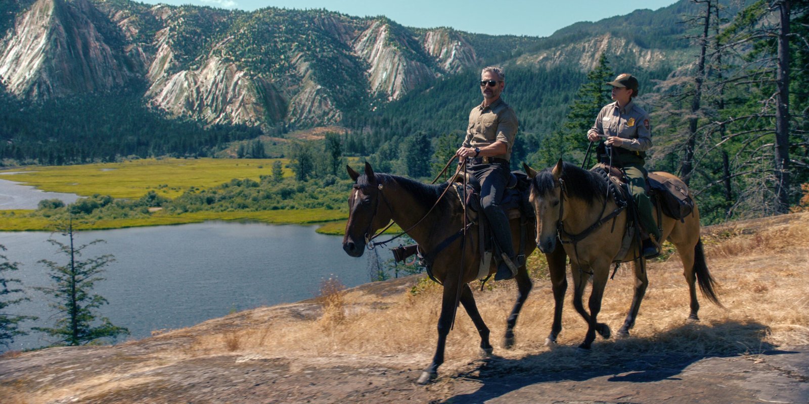
The Netflix series set in Yosemite didn’t film there, so our national parks columnist shares its overlooked places that deserve the spotlight.
“Untamed,” a Netflix series, is set in Yosemite National Park but was primarily filmed in British Columbia, Canada. (Photo: Courtesy of Netflix © 2025)
Yosemite National Park is gorgeous. That was my first impression when I watched the pilot of Untamed, the Netflix drama that follows a ranger investigating a murder inside one of the most iconic parks in the country. A lot of viewers—and National Park experts— expressed frustration with the show, mostly because the producers got a lot of the details wrong, from the human history of the park to the depiction of search and rescue procedures. Oh, and the fact that the majority of the show wasn’t even filmed inside Yosemite is a major point of contention. Most of the show was filmed in British Columbia, Canada, and according to Netflix, stand-ins included Mount Seymour and Callaghan Valley in Whistler. But the opening scenes of the first episode prominently features Yosemite Valley with a couple of dramatic bird’s eye view angles of the park’s granite that are absolutely mesmerizing.
I saw the opening sequence and I didn’t care what the rest of the show was about. I just wanted to see more of that landscape. John DeGrazio, founder of YExplore, a guide service in Yosemite National Park that specializes in photography hikes, understands the allure of that landscape.
“I was drawn in by the Valley during my first visit in 2003, so much so that my wife and I decided to move here without knowing a soul,” DeGrazio says. “I had visited a lot of other national parks, but Yosemite has this intrinsic magic to it. John Muir nailed it when he said the Valley was unparalleled.”
Beyond Yosemite Valley, Landscapes That Deserve the Spotlight
It’s dramatic landscapes make a intriguing setting for TV show, even a melodrama that gets a lot of the details wrong. But here’s the thing about Yosemite National Park: the landscape is just as stunning when you leave the Valley.
“The Valley is only percent of the park,” DeGrazio says. “Start walking away from the crowds and not only will you find solitude, you’ll find more granite domes and meadows and lakes…the diversity of landscape inside the park gives you a variety of scenes with a lot of awe factor. Anywhere you turn, you can find a sense of magic.”
Half Dome, El Capitan, Yosemite Falls … you could spend a lifetime staring at these landmarks from the Valley floor, but you’d miss out on some of the most amazing views in the park. Here are seven of the most photogenic scenes, from the edge of Yosemite Valley to the park’s less-crowded backcountry that deserve the spotlight, too.
Cathedral Lakes
There are more than 3,200 natural lakes inside Yosemite National Park, but a solid argument could be made that Cathedral Lakes, a watery duo in the High Sierra near Toulomne Meadows, are the fairest of the bunch. The 10,916-foot tall Cathedral Peak rises directly from the edge of Upper Cathedral Lake, while Lower Cathedral has broad expanses of sloping granite dropping down to its shore. Lower Cathedral also offers an expansive view of the Sierra High Country, including Tenaya Lake, from its shore.
How to Get There
Reaching the Cathedral Lakes requires a nine-mile hike out and back on a piece of the John Muir Trail from the Cathedral Lakes Trailhead, in the Tuolumne Meadows area. It’s a popular trailhead, but the crowds will be nothing like what you experience inside the Valley. The hike itself would be a worthy adventure even if it didn’t end at a couple of gorgeous lakes, as it passes through meadows and requires the occasional creek crossing. A half-mile spur trail leads to Lower Cathedral, which is the more popular destination, but I say visit both.
North Dome
North Dome itself is an impressive piece of granite, rising to 7,546 feet along the northern rim of Yosemite Valley, but you want to summit this mountain because of its view of a more famous piece of granite, Half Dome, which is directly across the Valley floor. Some have made the argument that the view of Half Dome from North Dome is the best in the park. Maybe. You’ll also get to see El Capitan and Clouds Rest from this perch, not to mention a huge chunk of the Valley itself. This is a great alternative to hiking Half Dome or Clouds Rest.
How to Get There
The easiest way to reach North Dome is a nine-mile hike out and back from Tioga Pass from the Porcupine Creek Trailhead. You’ll bounce from forest to meadow until reaching the base of North Dome, then it’s a ramble along rounded granite to the summit. You’ll start seeing Half Dome as soon as you hit the granite, but keep going to the sloping edge for the best view. You’ll also have the option to take a 0.3-mile side hike to Indian Rock, Yosemite’s only natural arch.
Merced Grove of Giant Sequoias
Giant sequoias are the largest known trees in the world, with canopies that can stretch 300 feet towards the sky and trunks that can be 30 feet around. These are the massive redwoods that can be found on the slopes of the Sierra Nevada Mountains, and Yosemite National Park has three giant sequoia groves. The Merced Grove is the smallest of the lot, with about 20 behemoth trees. But its trees are just as big, if not bigger, than the other two groves and it’s the least crowded of the three forests, which means the photo you take of your hiking partner hugging a tree will be unique. The redwoods are scattered throughout a small area of forest, but there’s a cluster of five of them flanking the trail that makes for an awesome photo.
How to Get There
Hike the three-mile hike out and back on an old road bed from the Merced Grove Trailhead off of Big Oak Flat Road. It’s an easy hike during the warm months, or a challenging snowshoe or cross country ski during the winter. You’ll pass an old ranger cabin, which used to be the superintendent’s vacation cabin, along the way.
Sentinel Dome
You like mountains with 360-degree views? Sentinel Dome might have the best 360 view in the entire park, with something dramatic in almost every direction you look. Stand on top of Sentinel and you’ll see Yosemite Falls and El Capitan to the north, Nevada Falls and Half Dome to the east, and the Merced Canyon to the west. The view of Yosemite Falls is particularly good. That 2,425-foot waterfall has sections that are obscured from most vantage points, but you can see almost the entire ribbon of water from Sentinel.
How to Get There
It’s a 2.2-mile out and back hike on the Sentinel Dome Trail, off of Glacier Point Road. You’re not going to have the view to yourself, but it’s nice to share pretty things. You can tack on an extra couple of miles and create a five-mile loop that takes in Taft Point for another great view of El Capitan. If you can time your hike for sunset, and bring a headlamp for the hike back to your car, you won’t be sorry.
Gaylor Lakes
Remember when I said Cathedral Lakes were arguably the prettiest of Yosemite’s ponds? Gaylor Lakes are the other side of that argument. There are five different lakes inside this high elevation valley, all of which are surrounded by some combination of lush meadows, tan boulders, and granite ridges. So take your pick of photo opportunities here. Middle Gaylor Lake is flanked by sloping granite on one side and lush meadow on the other. Small, gray boulders dot the grassland and taller mountains, including Cathedral Peak, rise on the horizon. It’s a stunner. But you’ll also get to see Upper Granite Lake, which is nestled in the bottom of a dramatic bowl, and Lower Granite Lake, a narrow affair offering views of distant peaks.
How to Get There
It’s a three-mile round trip on the Gaylor Lakes Trail off of Tioga Road. It’s relatively easy going two-mile out and back with all kinds of eye candy along the way. Loop trails encircle both Middle and Upper Gaylor Lakes and people have been known to hike off-trail throughout this pristine basin, so give yourself time to explore.
Lembert Dome
Tired of looking at Half Dome and El Cap? No, but there are other views, like from the top of Lembert Dome, a 9,449-foot tall hunk of granite that overlooks Tuolomne Meadows and its surrounding peaks. From the top of Lembert, you get a bird’s eye view of the massive meadow below. You’ll see smaller domes popping out of the forest, and the Tuolomne River carving a sinuous route through the grass. The horizon is dominated by peaks, like Cathedral and Mount Dana. But you could argue that the view from the meadow looking towards Lembert Dome is equally impressive, as the distinctive granite dome rises dramatically from the dark green forest.
How to Get There
Start from the Lembert Dome Trailhead on the edge of Tuolomne Meadows off of Tioga Road. It’s a straightforward hike through the forest at first, then you hit the exposed rock of Lembert and it’s a choose your own adventure to the top. You can also create a five-mile lollipop loop that summits the dome and wraps around Dog Lake, a small pond surrounded by forest.
Chilnualna Falls
Much like Yosemite Falls, Chilnualna Falls is a beast with so many different tiers, it can’t be seen from a single perspective. Unlike Yosemite Falls, you won’t stand in line for a great photo, as its remote location and tough hike keep the crowds at bay. Chilnualna is a collection of five different cascades that drop a total of 700 feet through a granite gorge. The tallest tier is over 300 feet, but it’s the 50-foot Lower Chilnualna Falls that’s arguably the most dramatic and offers the best photo, as it’s flanked by granite walls dropping into a pretty pool at the bottom. There are plenty of chances to get up close and personal to this falls. You can even scramble up to the next tier to find another drop and pool. Peak runoff in early summer is when it’s most dramatic, but it’s beautiful year round.
How to Get There
Start at the Chilnualna Falls Trailhead off of Chilnualna Falls Road in southern Yosemite. It’s a tough hike that begins along the creek, but quickly starts climbing through the forest via a series of switchbacks. The climbing doesn’t really stop until you reach the falls. All in, you’ll climb 2,500 feet during this 8.5-mile roundtrip hike that doesn’t get a lot of attention, so you won’t need to fight crowds to get your shot.
Watch Our Tips for Visiting Crowded (and Underfunded) National Parks This Summer
Graham Averill is Outside magazine’s national parks columnist. One of his most memorable backpacking trips was inside Yosemite National Park. He recently wrote about the perfect summer road trip through West Virginia.
Graham Averill is Outside’s National Parks columnist, as well as a gear columnist for the magazine, spending most of his time writing about travel and the equipment he uses while traveling.
He grew up in the South before bouncing around the West where he studied at the University of Colorado and fell in love with skiing, surfing, and mountain biking. Eventually he and his wife settled down in the Southern Appalachians because it’s the only place in America where you can get boiled peanuts from a roadside stand.
He’s contributed to a wide range of magazines, from Bike mag to AARP, and he really likes to write stories about pushing his own limits. Also, he jumps at the opportunity to write about his truck.
Destinations & Things To Do
Cheapest Country to Travel from India: Top Budget-Friendly Destinations – Elle India

-

 Brand Stories3 weeks ago
Bloom Hotels: A Modern Vision of Hospitality Redefining Travel
-

 Brand Stories2 weeks ago
CheQin.ai sets a new standard for hotel booking with its AI capabilities: empowering travellers to bargain, choose the best, and book with clarity.
-

 Destinations & Things To Do3 weeks ago
Untouched Destinations: Stunning Hidden Gems You Must Visit
-

 Destinations & Things To Do2 weeks ago
This Hidden Beach in India Glows at Night-But Only in One Secret Season
-

 AI in Travel3 weeks ago
AI Travel Revolution: Must-Have Guide to the Best Experience
-

 Brand Stories1 month ago
Voice AI Startup ElevenLabs Plans to Add Hubs Around the World
-

 Brand Stories4 weeks ago
How Elon Musk’s rogue Grok chatbot became a cautionary AI tale
-

 Brand Stories2 weeks ago
Contactless Hospitality: Why Remote Management Technology Is Key to Seamless Guest Experiences
-

 Asia Travel Pulse1 month ago
Looking For Adventure In Asia? Here Are 7 Epic Destinations You Need To Experience At Least Once – Zee News
-

 AI in Travel1 month ago
‘Will AI take my job?’ A trip to a Beijing fortune-telling bar to see what lies ahead | China
You must be logged in to post a comment Login