
Destinations & Things To Do
Block Island, Chattanooga, Door County, Sawtooth National Recreation Area, and St. Simons Island: Know More About The Top Five Underrated Travel Destinations in the U.S. and Their Impact on Tourism
Monday, July 28, 2025
In the summer of 2025, when vacationers cram popular tourist havens across the US, a handful of under-the-radar destinations are beckoning with singular experiences. These underrated destinations, which are often overshadowed by more famous cities and landmarks, are gaining a reputation among travelers for those looking for something different. From uncrowded islands and pristine coves to well-preserved churches and long-standing capitals, these must-visit gems offer a host of great things to see and do.
Discovering Under-the-Radar U.S. Destinations: The Latest in Travel Trends
With the changing face of tourism, a growing number of travelers want something different: a vacation that’s more personalized, less crowded, and more affordable. Social media, including apps like Instagram and TikTok, has spawned a move towards finding destinations that are less commercial. Castle-like stone structures, preserved Old-West towns and unmatched natural beauty are just a few of the attractions calling your name when you choose to hit the road less traveled in the U.S. This collection of the top five underrated destinations in the U.S., as recently reported by U.S. News & World Report, is all about that — a combination of untouched beauty, historical value and the sort of pace that helps travelers let go of their stress.
Although definitely not yet garnering high volumes of crowded tourists like New York City, Los Angeles, or the Grand Canyon, these under-the-radar spots are where it’s at. From the beaches of St. Simons Island to the restful mountains of Sawtooth National Recreation Area, these are the places that inspire us to travel — though we can’t guarantee there won’t be a crowd (except at those beaches, of course). This change in travel demand has also influenced the local and national tourism industry, as travelers have tried to avoid mass tourism.
Block Island, off the coast of Rhode Island, is not as well-known as Nantucket or Martha’s Vineyard, but it has a snug, unassuming appeal that’s tough to match. The island boasts 17 miles of beautiful beaches with plenty of room for swimming, sunbathing and beachcombing. Guests can also visit two historic lighthouses, including the National Register of Historic Places-listed Block Island Southeast Lighthouse.
For nature lovers, Block Island has hiking, biking and bird-watching opportunities in droves. The Block Island Maritime Institute is a great place to learn about the island’s ocean environment. Block Island’s relatively laid-back vibe makes it a perfect getaway for anyone interested in being an ocean frolic away from the racket of crowded beach towns. The island’s leisurely lifestyle has drawn both domestic and foreign profiteers, who are helping to promote local tourism and provide profits to the small local businesses at which Tucker and Yotman have spent the past year drinking and socializing.
“The appeal of Block Island is its peace and unadulterated beauty. The island provide a refuge from the busy shores of other East Coast beach towns, so it’s the perfect place for people in search of peace and quiet and history and nature. The Block Island trend is reflective of a larger movement in which travelers are searching for less-crowded beach spots, a trend that is helping to diversify the U.S. travel industry.
Buried in the shadow of Nashville and Atlanta, Chattanooga, Tennessee, is living proof of being another hidden gem in the South. Dubbed the “Scenic City,” Chattanooga is situated along the Tennessee River with beautiful views of the mountains. The picturesque downtown area of the city is full of cultural sights like the Tennessee Aquarium and the iconic Walnut Street Bridge, one of the world’s longest pedestrian bridges.
Outdoor enthusiasts will also not be disappointed in Chattanooga. Lookout Mountain, which is a short drive away, has impressive sweeping views of seven states from the summit, and features attractions like Rock City Gardens and Ruby Falls. The city’s natural bounty has turned it into a magnet for hikers, rock climbers and zip-liners. Furthermore, the reasonable prices and kid-friendly activities in Chattanooga provide added incentive for local and foreign travelers alike.
It is a boom for tourists that has helped rejuvenate the local economy, enticing visitors to the city by being an unusual union of history, culture and outdoor adventure. As travelers increasingly crave those off-the-beaten-path destinations, Chattanooga has really epitomized a mini city that packs the same punch as a larger city, with the added bonus of not as much traffic and packing in and packing out.
Door County is situated on the Door Peninsula in Wisconsin and is commonly known as the “Cape Cod of the Midwest.” And with six state parks to its name, it’s always a good time for outdoor enthusiasts. During the winter, Door County’s frozen lakes are an open field for cross-country skiing and snowshoeing, and in the summer, boating, fishing and hiking are popular activities visitors participate in.
The county has many gracious small towns, art galleries and delicious, local food, and well known cherry orchards. The beautiful landscapes and the comfortable hospitality of Door County’s charming bed and breakfasts and inns make it a great place for travelers seeking a break from the busyness of other tourism-infested destinations. Though Door must fend off more and more tourists, the area Is still committed to more responsible tourism, and much of the natural beauty has been saved for future generations.
The positive effects of tourism growth in Door County can be seen in the region’s economy – it’s booming. Not so large: The more visitors there are in a state, the more the demand for local, boutique businesses, such as family farms, vineyards, and craft stores. The year-round appeal of Door County also contributes to a steady flow of visitors, which sustains the local economy in all seasons. Door County’s emergence as a hot spot draws attention to the increasing interest in travelers looking for close, community experiences.
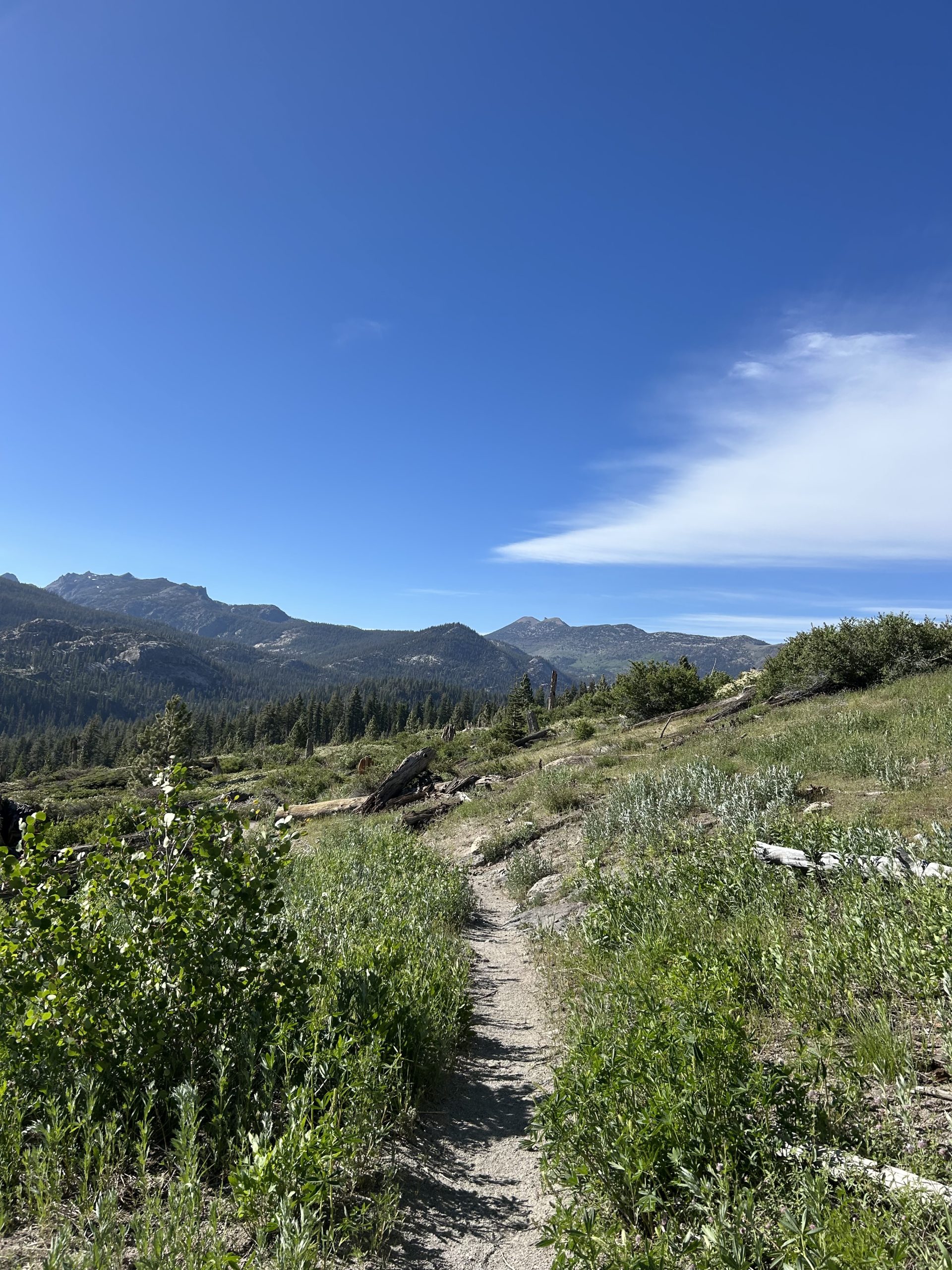
Sawtooth National Recreation Area, in central Idaho is a breathtaking example of the power and beauty of nature. The area, which encompasses more than 700 acres, is dotted with hundreds of alpine lakes, including the renowned Redfish Lake. With its rugged mountain terrain, clear blue lakes, and wildlife plethora, Sawtooth National Recreation Area is a destination for hikers, kayakers, and for those who seek an adventure in the wild.
Visitors can hike more than 700 miles of trails, making it one of the best places for hiking in the United States. The region’s unspoiled beauty and untouched terrains offer a paradise for outdoor enthusiasts looking to avoid the crowds at more popular national parks. The increasing visibility of Sawtooth is part of a larger trend: A higher number of travelers are searching for undiscovered, less-frequented destinations that provide natural immersion without the heavy foot traffic of better-known parks.
The impact of Sawtooth’s tourism on local communities is also significant, as outdoor tourism is often related to greater consumption in nearby towns. Businesses and hotels, along with camping opportunities, also profit from the flood of crowds, bringing in millions to Idaho’s tourism economy.
Golden Isles – St. Simons Island Georgia’s Golden Isles St. Simons Island is the largest of Georgia’s Golden Isles and is the perfect escape for a tranquil yet beautiful barrier island. Celebrated for its mild temperatures, gorgeous beaches, and historic landmarks, St. Simons Island has emerged as the go-to spot for visitors seeking a taste of Southern charm, without the traffic and flashy neon signs of other seaside hubs.
With a history that is rich, featuring its role in the Civil War and a historic lighthouse, the Island, is a history buff’s paradise of a location. St. Simons Island also features numerous dining, shopping, and outdoor offerings with nearby hiking, biking and kayaking. With a laid back vibe and gorgeous beaches, what a great place for relaxation in the midst of small town charm.
There is no denying the affects of St. Simons Island tourism on the local economy, as the crowds of vacationers become larger every year. By maintaining its commitment to the preservation of the island’s natural beauty and encouraging sustainable tourism, St. Simons Island remains a desirable vacation gateway that will continue attracting visitors for years to come.
Conclusion: Eastern European Hidden Gem Destinations that Will Change Your Travelling Perspective
Rise and shining For Block Island, Chattanooga, Door County, the Sawtooth National Recreation Area and St. Simons Island to rise on a list of underrated destinations is to reflect a change in global travel tastes. Nowadays, they are becoming more and more known for their individual character, natural beauty and historical past, as travelers are looking for more individual and authentic experiences. The world of tourism is now paying increasing attention to these hidden treasures offering opportunities to discover less known, but equally attractions.
These days, individual communes profit from receiving visitors in the form of tourist spending into the local economy012.pdf) For the local economy, the flow of tourists to these destinations is very positive. Small businesses, small farms and outdoor service providers experience upticks in demand, leading to a more sustainable model of sex tourism. As travelers continue to look for fresh and authentic adventures, the future of travel is in recognizing these undiscovered havens and the promise they hold for once-in-a-lifetime experiences.


*these posts are coming straight from trail, I apologize in advance for typos!*
Location: High Sierra
Start: Mammoth Lakes – 904.4
End: Mammoth Lakes – 904.4
Miles: 0.0
Ascent: 5562 | Descent: 5562
Sleep: Building
What a big day! We woke up around 4am at a beautiful campsite just outside of Yosemite. We wanted to get into the park early and had about an hour drive to the trailhead, so we left the national forest campsite around 5am. We made it to Curry Village inside of Yosemite around 6am and were heading towards the Mist Trailhead around 6:30am.
Back on Saturday we all applied for Half Dome cable permits while eating pizza in Mammoth. We didn’t think we’d get any of the last minute permits issued, but lo and behold Truffles application for 5 permits was approved! This felt like a once in a lifetime opportunity and we knew we had to make it up Half Dome. We had about a mile walk along the road to get us to the trailhead, and once we were on the Mist Trail we started climbing uphill.
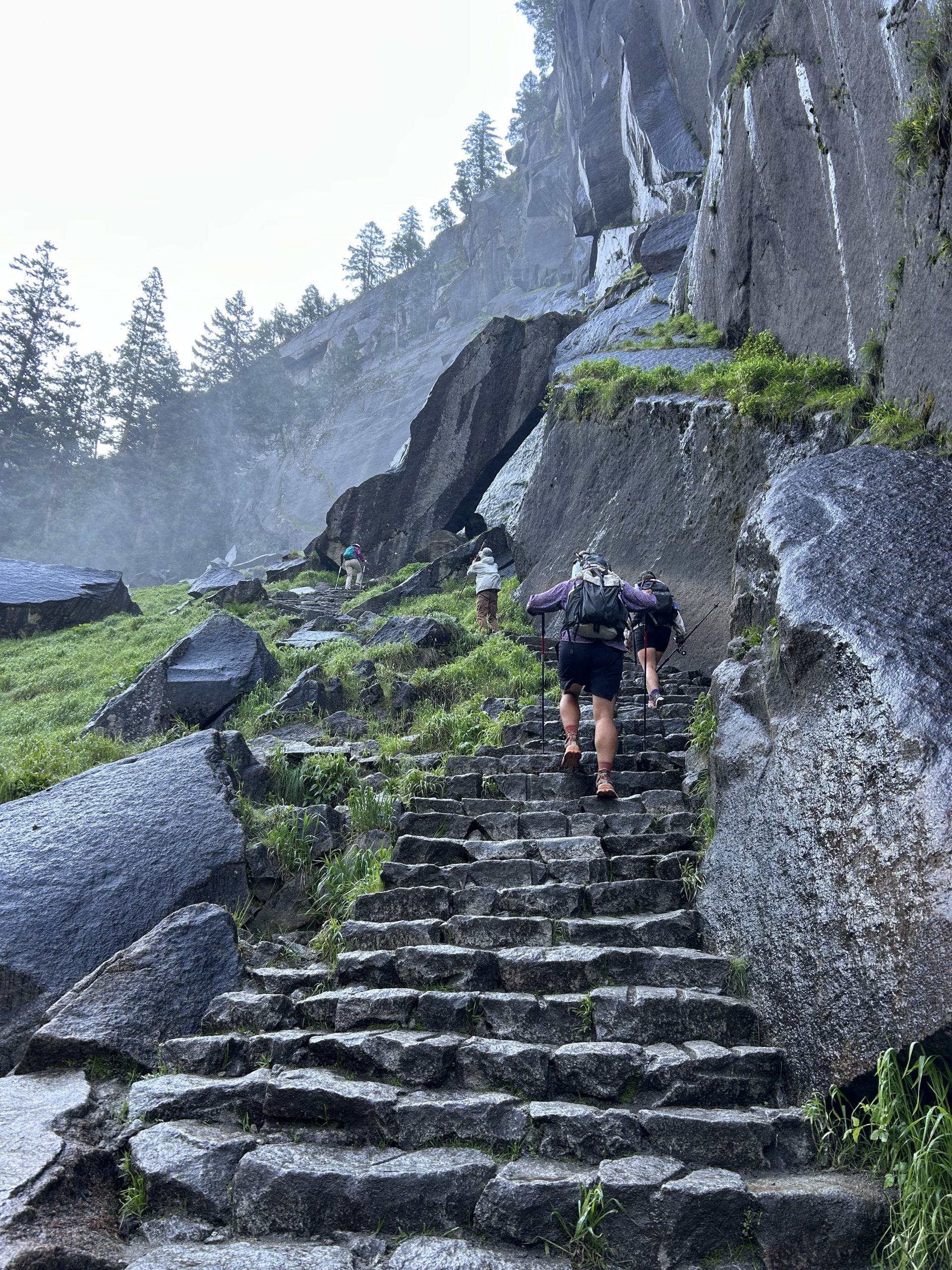
The beginning of the trail was paved and covered with people, even before 7am. Apparently 300 permits are issued for the cables every day, but you don’t need permits to hike up to the waterfalls along the trial and. It’s a hard hike and not for the faint of heart, but I couldn’t believe how many people there were the entire way up! We are in great shape and conditioned for long hikes, but holy shit the hike all the way up was super strenuous and hard! I was shocked by how many “normal people” we saw. Granted we did the trail faster than most of them, but we also had hiked 900 miles up to this point. We had a lot of conversations about day hikers and how impressed we were by the amount of people able to do the trail, it was that hard!
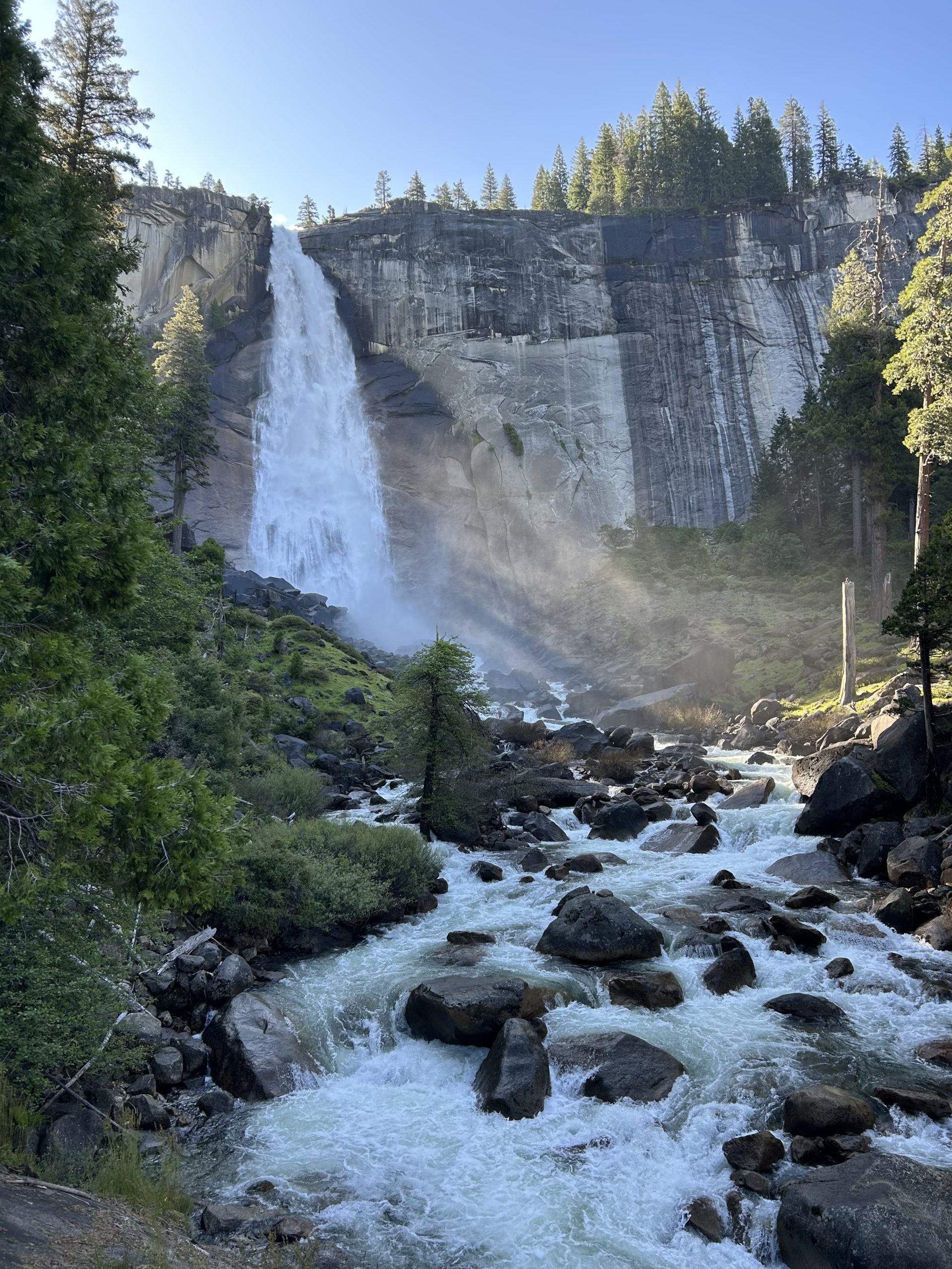
After a few miles we crossed the Vernal Falls Bridge and passed the water station and bathrooms. I couldn’t believe there were full on flush toilets on the mountain, what a luxury! There were lots of signs about how much water you’d need based on what time you were doing. Obviously it was necessary information because of how ill prepared many people were on the trail. I saw lots of flip flops and people that didn’t have water or daypacks or anything…
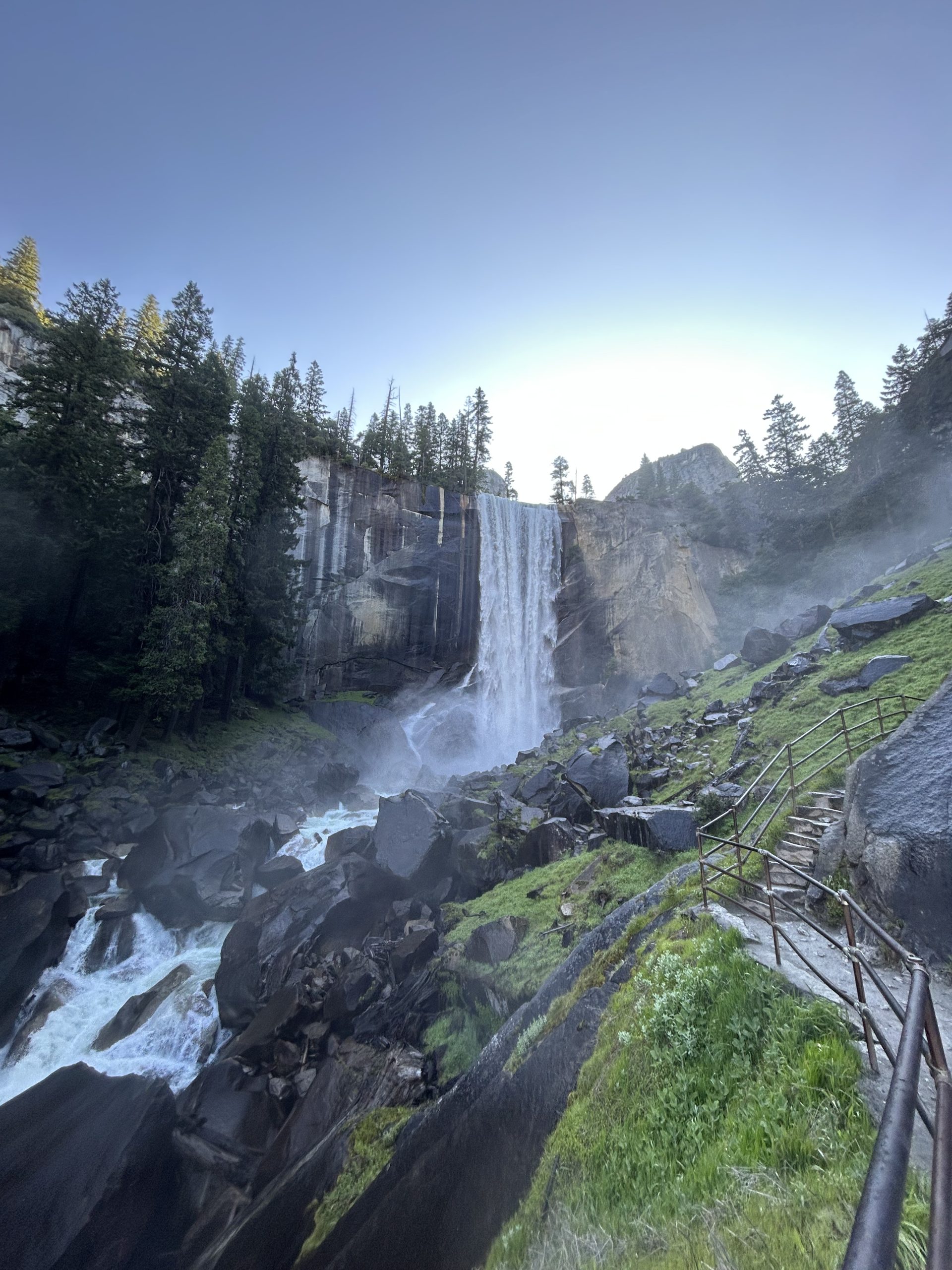
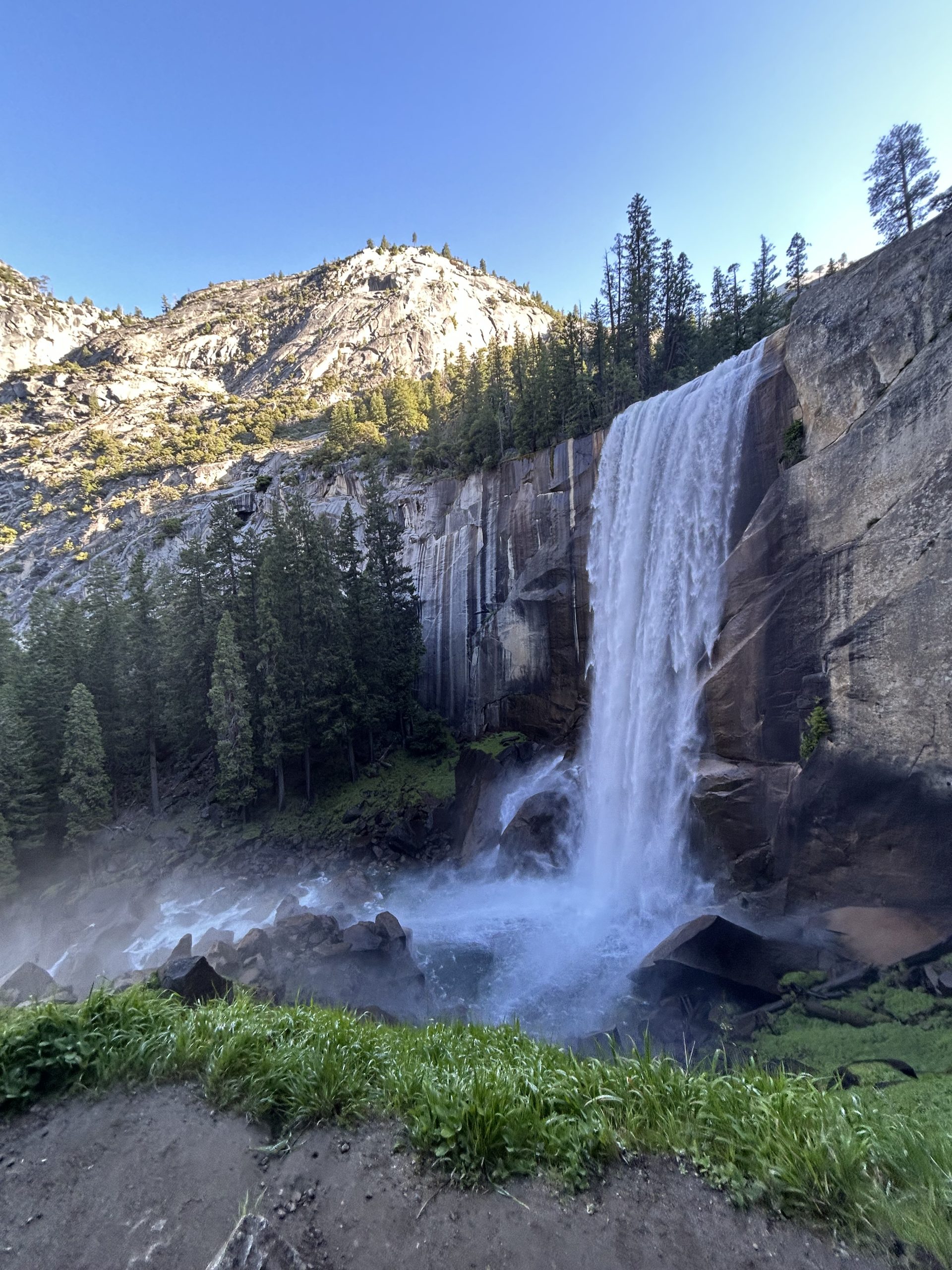
From the bridge we continued climbing up towards Vernal Falls. The water fall was huge and we got super close to it thanks to a ton of stairs. We hiked near the actual falls and ended up on top of the waterfall where the river began its plunge over the cliff. The trail took us past Emerald Pool and continued climbing up towards Nevada Falls. We crossed another bridge and took even more stairs up towards the fall.
After countless stairs and several switchbacks, we were at a junction and yet another bathroom opportunity. This was just a pit toilet, but still what a wonderful reprieve. The trail leveled out significantly for the next several miles and we just cruised along the dirt path. We passed so many people, many of whom were ambitiously heading towards the cables as we were.
When we hit the forest we began to climb yet again. The elevation gain was wild because it felt like we did a ton of climbing in the beginning of the trail, has a break in the middle, and then did a bunch more climbing at the end. We just kept going up and up and up and eventually ended up at the base of the sub dome. There was whiteboard warning hikers not to go up during inclement weather as well as reminding people that permits were required. We didn’t see a ranger and proceeded up towards the sub dome.
This section of the hike was climbing up the granite slab with some cut out stairs and some rock scrambling. I felt comfortable traversing the rock but tried not to spend too much time looking around out of fear that I’d scare myself and freeze. My fear of heights hadn’t been paralyzing yet, but I didn’t want to hinder myself in any way.
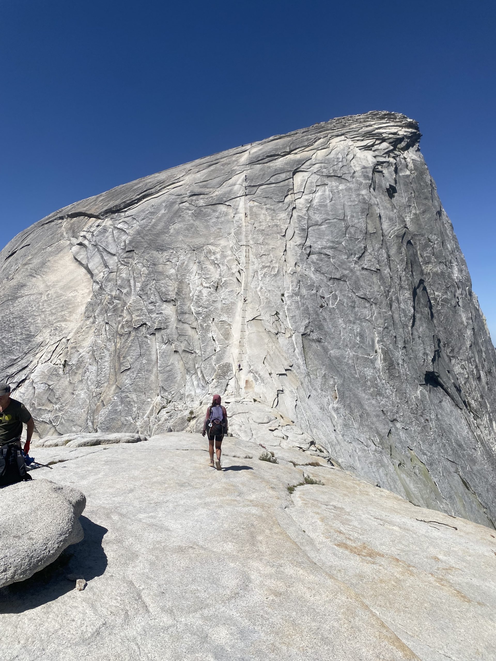
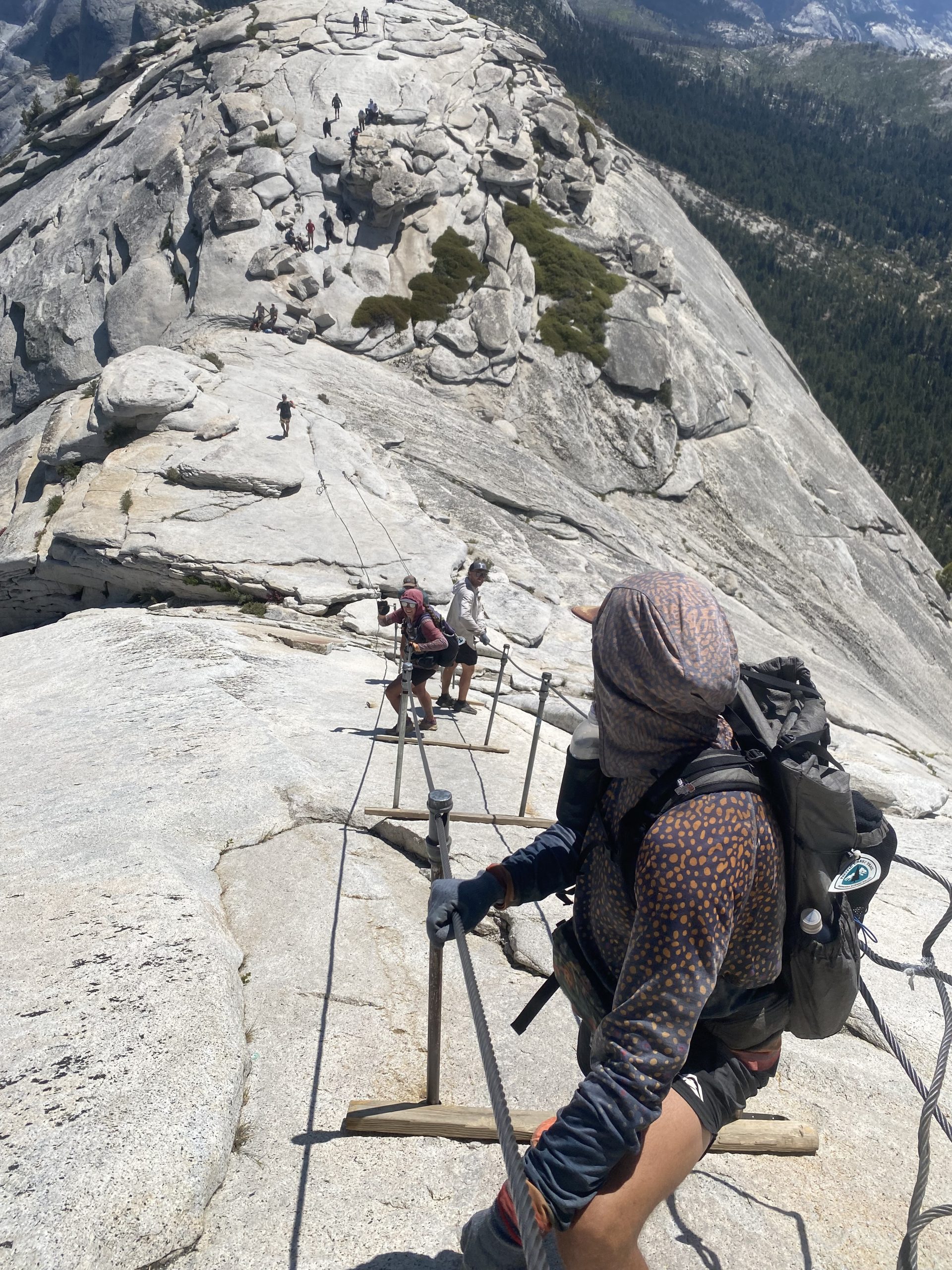
When we crested the sub dome it started to get real. The cables were right in front of us and it looked like they went straight up the mountain. The section was about 600 feet long and it looked like people were propelling themselves up the rock face by just hanging onto the cables. I knew that it would be too steep for me to attempt the summit, but my friends were insistent that I at least give it a try.
Reluctantly I went to the base of the cables. We all found some gloves that were left by the cables and gratefully put those on. We got into a line and began the slow ascent. I stayed in the back so that it would be easy for me to turn around if I decided I couldn’t do it. I made it maybe 20 feet and got really scared. I started shaking and could feel tears coming on and I told our group I was turning around. They were understandably disappointed and gave me a hard time as I started making my way back down.
I felt so much better when I was on solid ground again. I was disappointed in myself but knew I would have lost my mind if I got even further up and tried to come back down. I found a spot in the shade to sit and wait and ended up having a great time watching the slow progression of people up and down the cables. It took my friends about an hour to get up and down, including the time they hung out on top. Watching them all come down was so nerve wracking because there were so many other people on the cables. There was no order in which people would go up and come down, so people were going in and out of the cables trying to pass one another. It was scary knowing one misstep would be the end of my loved ones. I tried not to focus on that as I watched my friends slowly descending the slab of rock.
Finally they were all safely on the ground. They excitedly told me about their climb and showed me pictures of the view from the top. We sat and hung out for a while watching other people go up and down on the cables before deciding we should go ahead and start the long descent back to the car.
Doing an out and back trail is always fun because I feel like you notice different things going in either direction. It felt like a completely different hike heading down the mountain, there were so many things I didn’t see before. I also didn’t realize how much climbing we did, but I certainly felt it on the way down. I was extra thankful for my trekking poles, especially on all the steep stairs we had to climb down. My knees were feeling it by the end!
It took us about 4 hours to get back to the car. We were all exhausted and limping by the time we finally reached the car. We were also very hungry, so we decided to go back to the visitor center to go to the grill for a snack. We downed some burgers and easily could have eaten more, but we Truffles was adamant he wanted (and deserved chicken wings). We used what little signal we had to look up where a Buffalo Wild Wings was and started driving in that direction.
Civilization was about 2 and a half hours away, but thankfully the drive was pretty and it went by fast. We got to the restaurant around 8pm and it took a long time for us to be seated but we were so tired and hungry it didn’t matter. We devoured the endless wings when we finally got sat and were able to order. We each ate at least 16 wings!
By the time we finished eating we figured it was too late to try and find a campsite. We opted instead to book a cheap hotel room online and were so happy to finally get to the hotel around 11pm. Our $150 room ended up being one of the nicest hotels I’ve stayed at! We were best and fell asleep as soon as we got in the room. What a big day, I’m so thankful to get to end it in a bed! According to Truffles Garmin we did 18.8 miles with 5500’ of elevation change each way. And to think this was technically an “off” day!
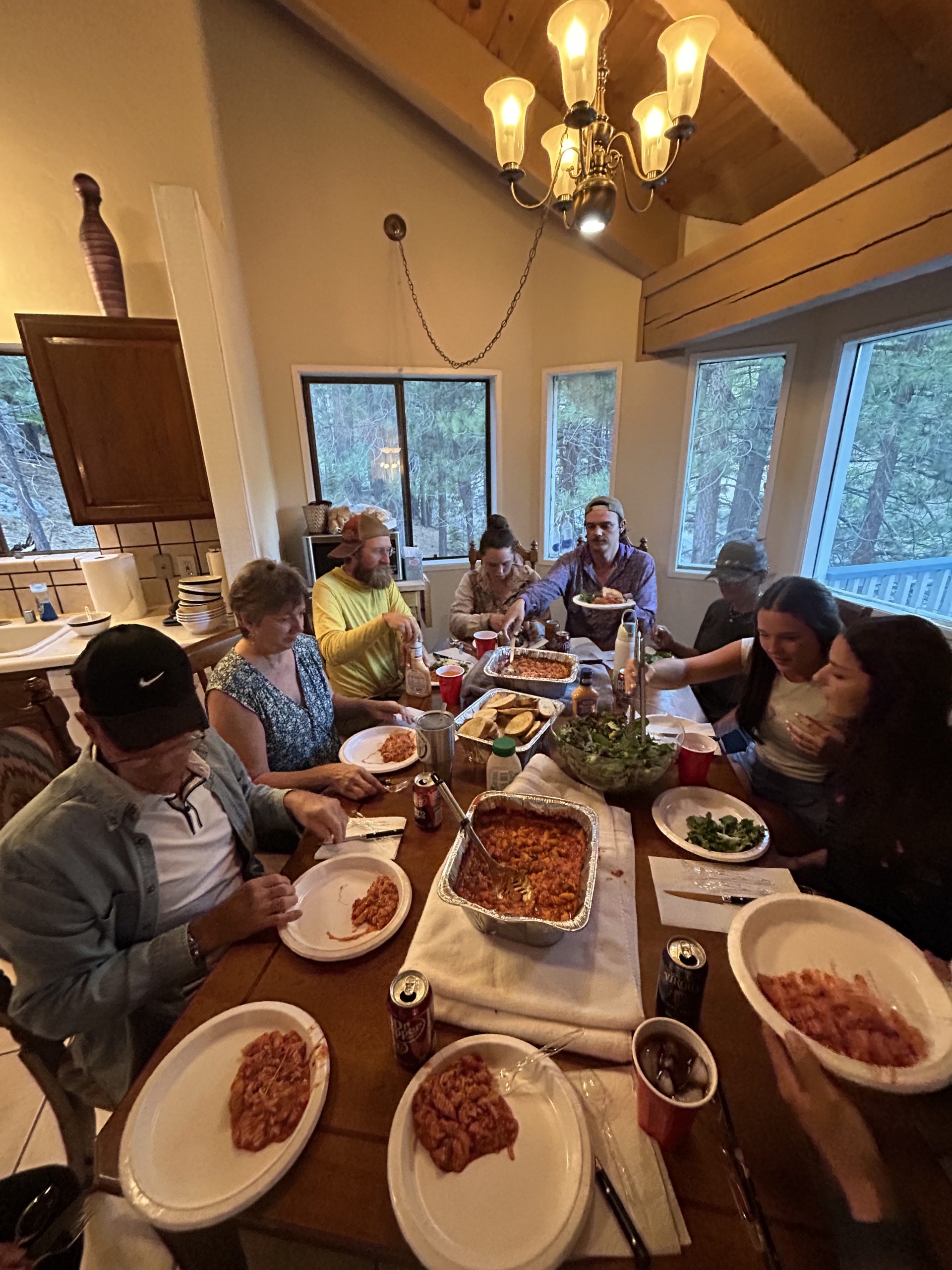
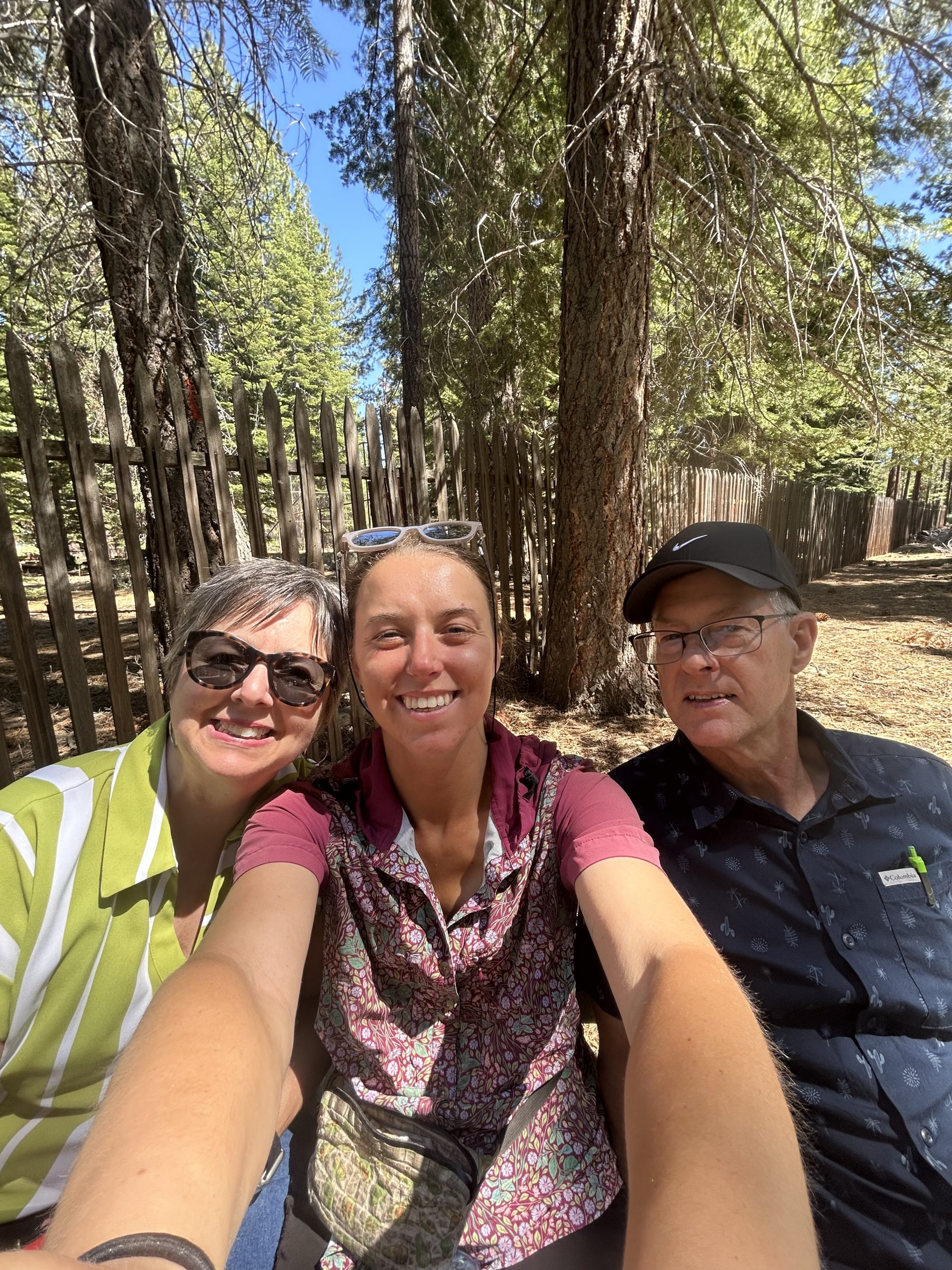
Our families flew out to see us in South Lake Tahoe! My parents along with Truffles and Hangman’s mom, plus Pinky’s mom and two younger sisters all made the trip. We rented a large house so we could all stay together and spent several days relaxing and sightseeing. It was the perfect break from hiking and so good to see family!
Location: High Sierra
Start: Manmoth Pass – 904.4
End: Red’s Meadow Junction – 907.9
Miles: 3.5
Ascent: 17 | Descent: 1276
Sleep: Tent
Back on trail after several glorious days off! I was worried I wouldn’t be happy once we were back on trail and that being around our families would make me feel homesick, but today was a great day and I felt very thankful to be out here.
Our families had morning flights out of Reno, so they all had to leave by 7:30am. I got up around 6:30am so k could drink coffee and spend time with my parents before they left. My parents are heading to Yellowstone after our visit to do some sightseeing of their own, so we talked about their trip and what they were excited about. It was sad to say goodbye to Hangman and Pinky, it doesn’t feel right being on trail without them. I think Hangman made the right call by choosing to go home and heal rather than trying to stay out here in hostels or hotels. It sucks that they have to go home and I know it will be hard to get back on trail, but he needs the time and space to heal. We are bummed and I know they are as well, but we’ll see them again in a few weeks!
Our families got out the door on time with lots of hugs and kisses goodbye. That just left Pimento, Truffles, and I. We hung out at the rental house for a few extra house taking our time with breakfast and packing up. We soaked up all the internet connectivity we could and were out there door around 10:30am.
It was just under a 3 hour drive from South Lake Tahoe to Mammoth Lakes. We made good time and only stoped along the way for bathroom breaks and to get a “real milkshake” (that ended up being delicious and was absolutely worth the stop). We got to the Horseshoe Lake trailhead to Mammoth Pass around 2pm. Pimento is planning to get back on trail tomorrow where he got off in Bishop, so he dropped us off and then was going to drive the rental car back down to Bishop. He’ll be about 2 weeks behind us but is planning to skip up to where we are when Pinky and Hangman return.
We said our goodbyes to Pimento and were hiking up the trail just after 2pm. We had about 3.5 miles back up to the PCT and then were going to find a campsite somewhere after that. I set out ahead and Truffles but figured he’d catch me soon. I stopped to wait at one point and when he didn’t show up after 15 minutes I started asking day hikers if they’d seen a solo guy in a blue shirt and big backpack. When no one had I got worried and decided to hike back down to the parking lot.
Truffles was no where in site and I frantically called him. I didn’t expect him to have signal but thank goodness he did and he picked up. Apparently he had taken an alternate trail to McLeod Lake and was waiting for me there. I was aggravated but he was apologetic when I finally found him. Now that it’s just the two of us out here I really want us to stay together and I felt panicked that we wouldn’t have any way to reach one another if we were separated. We were reunited at the lake and continued to hike on together.
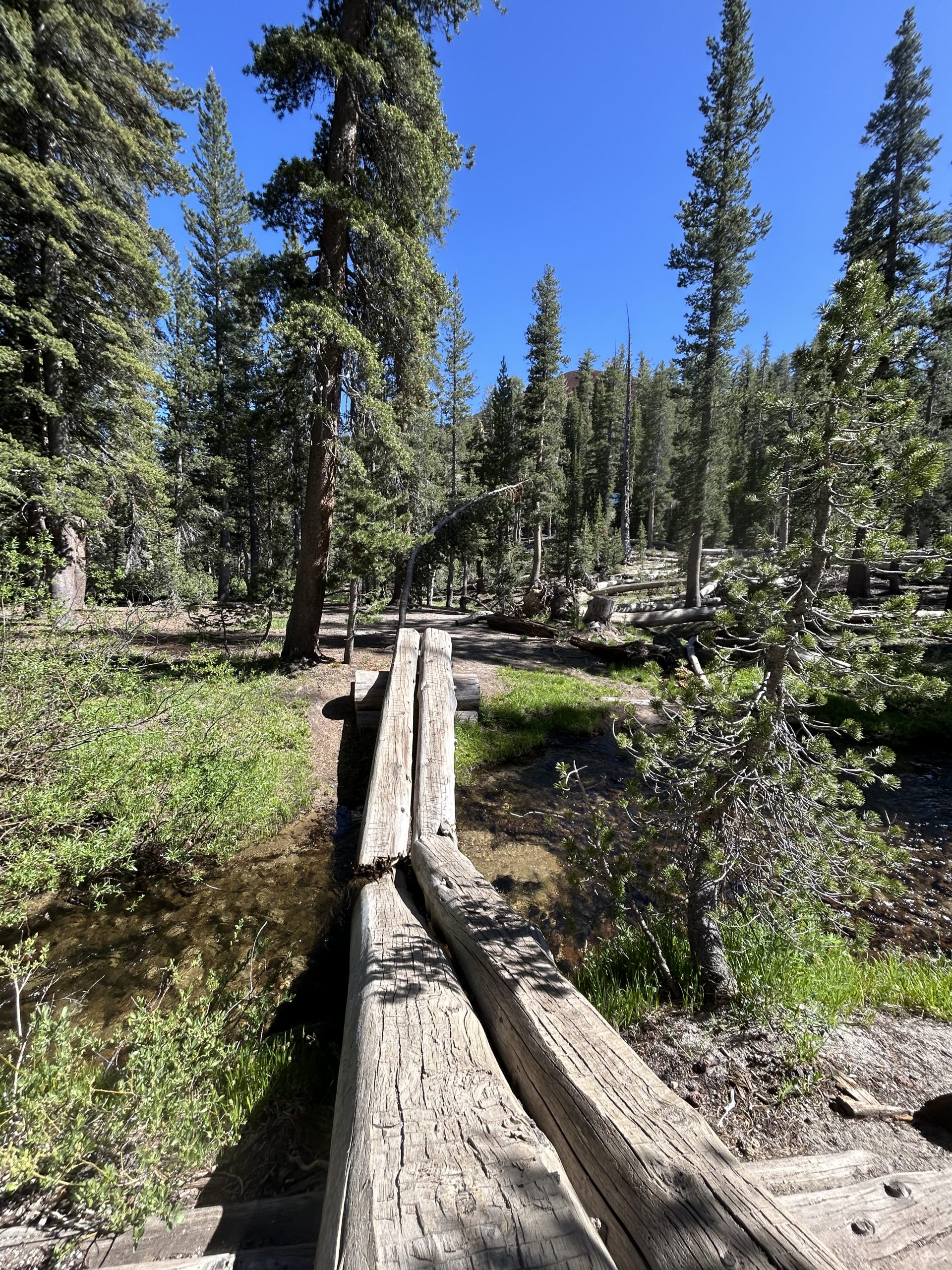
The trail back to the PCT wasn’t nearly as bad as I remembered it being. I had been dreading the hike up, but it ended up being pretty mellow with very mild uphills and a good amount of downhill. We were back on the PCT before 4pm and decided to head towards the junction to Red’s Meadow. Truffles had to dig a cat hole but we made plans to meet and get water near the junction.
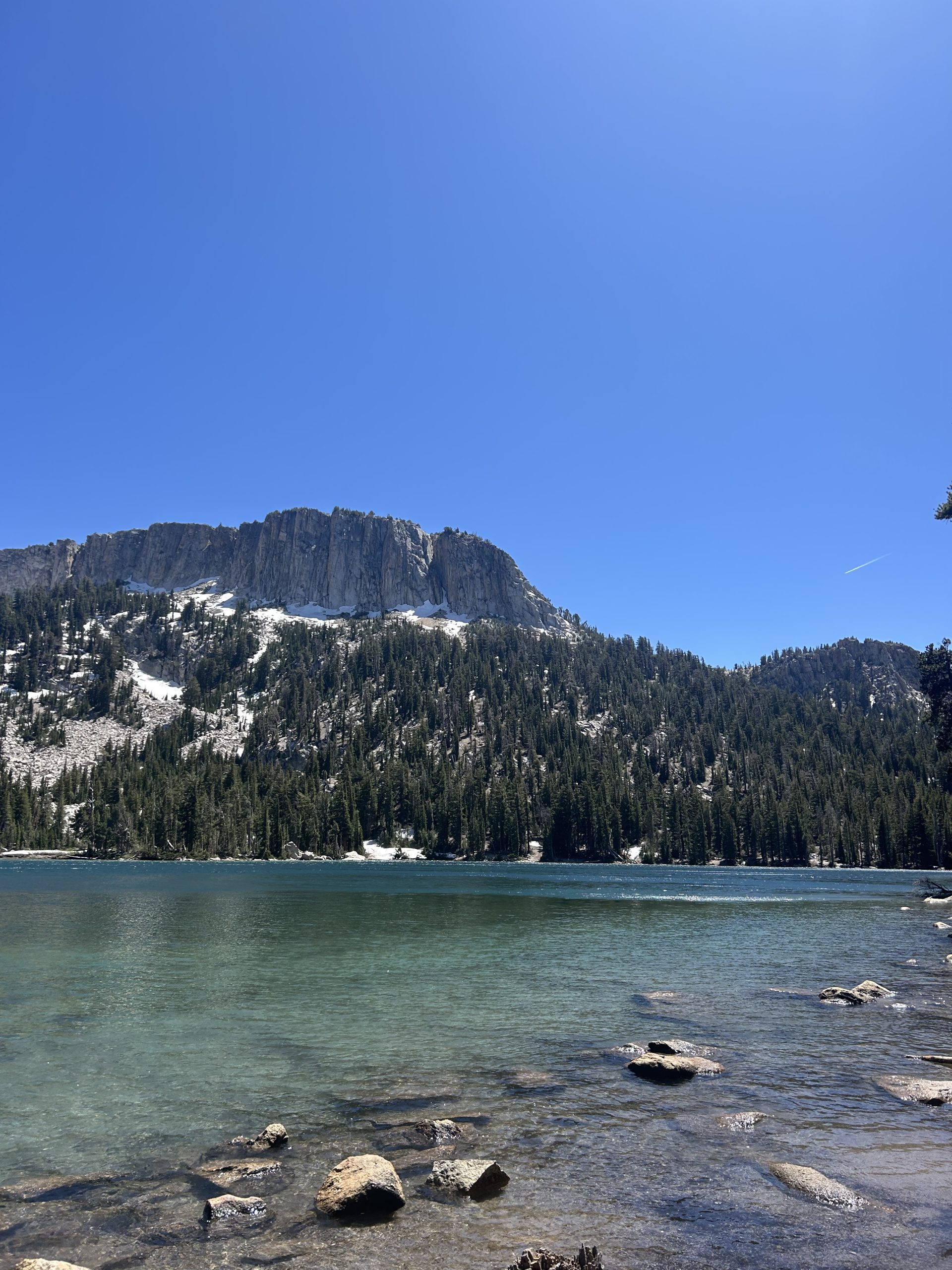
The trail this afternoon was beautiful! I hiked through tall pine forests and over multiple babbling brooks. There were areas that were sunny and exposed, but for the most part things look really green and lush (especially around the water). I didn’t hike through any snow today, I guess summer is in full force and the snow melt has made way for greenery. I paused at several of the water sources to admire the moss and flowers, it reminded me of home. The big difference was the huge snow capped mountains in the distance.
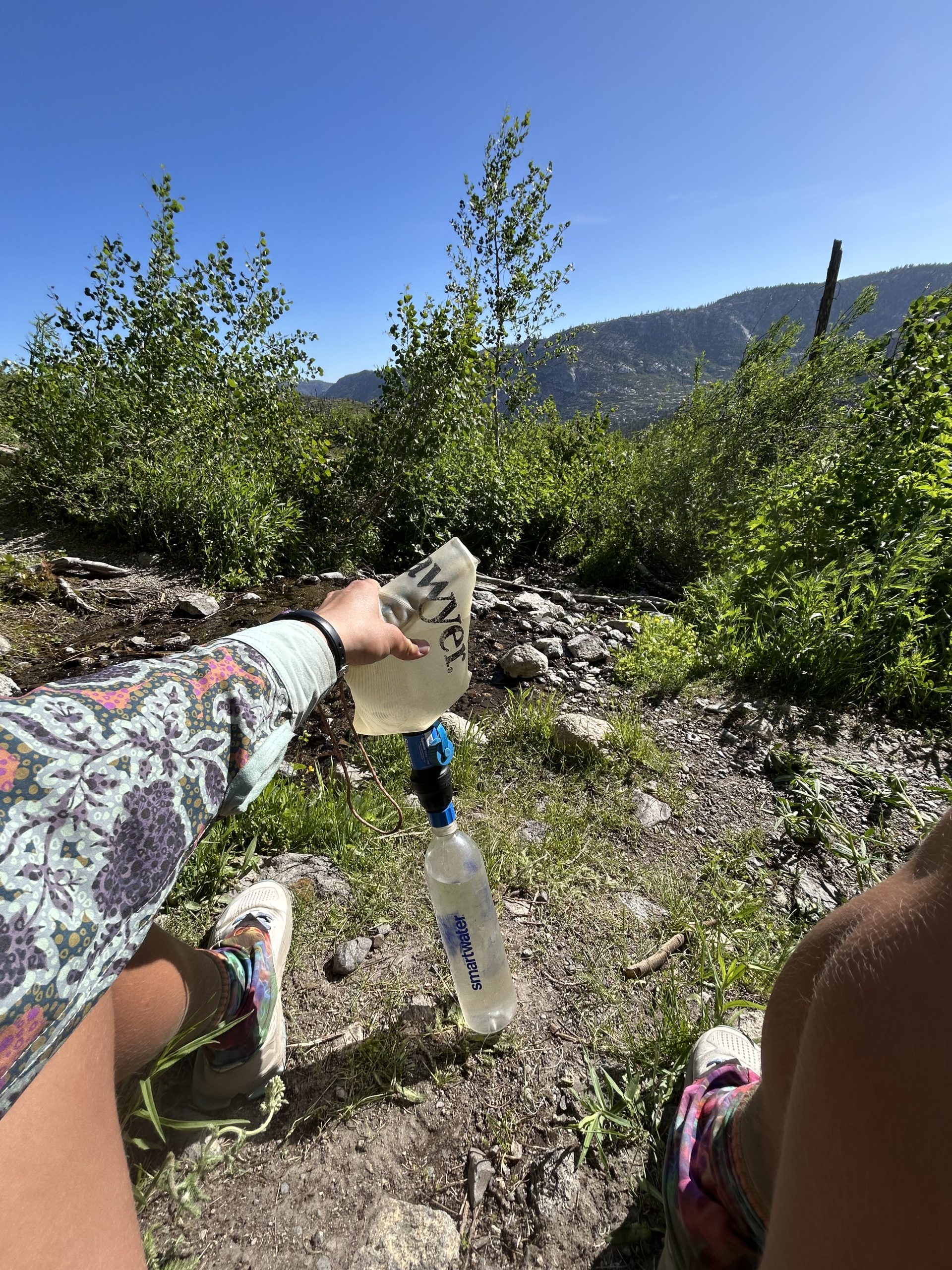
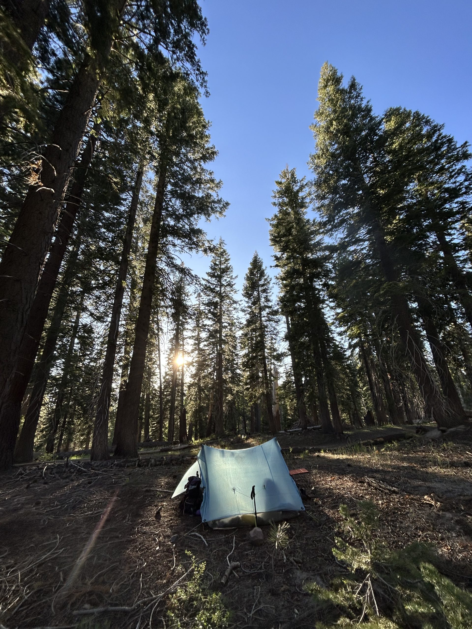
I stopped at our planned water source to filter water for the evening. Since we weren’t sure where we would camp was wanted to be sure we’d have water in case we chose a dry campsite. Truffles caught up and decided to go a little further. We met back up at the junction and continued on together for a bit before seeing some nice campsites down off the trail. Unfortunately it was a dry campsite but we had plenty of water to get us through the evening and tomorrow morning.
We set up the tent and were thankful the mosquitos weren’t out before of how windy it was. In the sunshine the wind was okay, but I know it will be chilly when the sun goes down. We made dinner and talked about our family’s visit and about how crazy it is to just be the two of us. Today is our two year wedding anniversary so we talked about all the adventures we’re had together the past couple of years.
We’re both worn out after our time away from trail, so we got in the tent early. Again the wind is chilly so we were happy to snuggle up in our sleeping backs. I think we’ll enter Yosemite tomorrow! We did 7 total miles today: 3.5 back to the PCT and 3.5 nobo on the PCT. A nice little re-entry after not hiking for a few days.

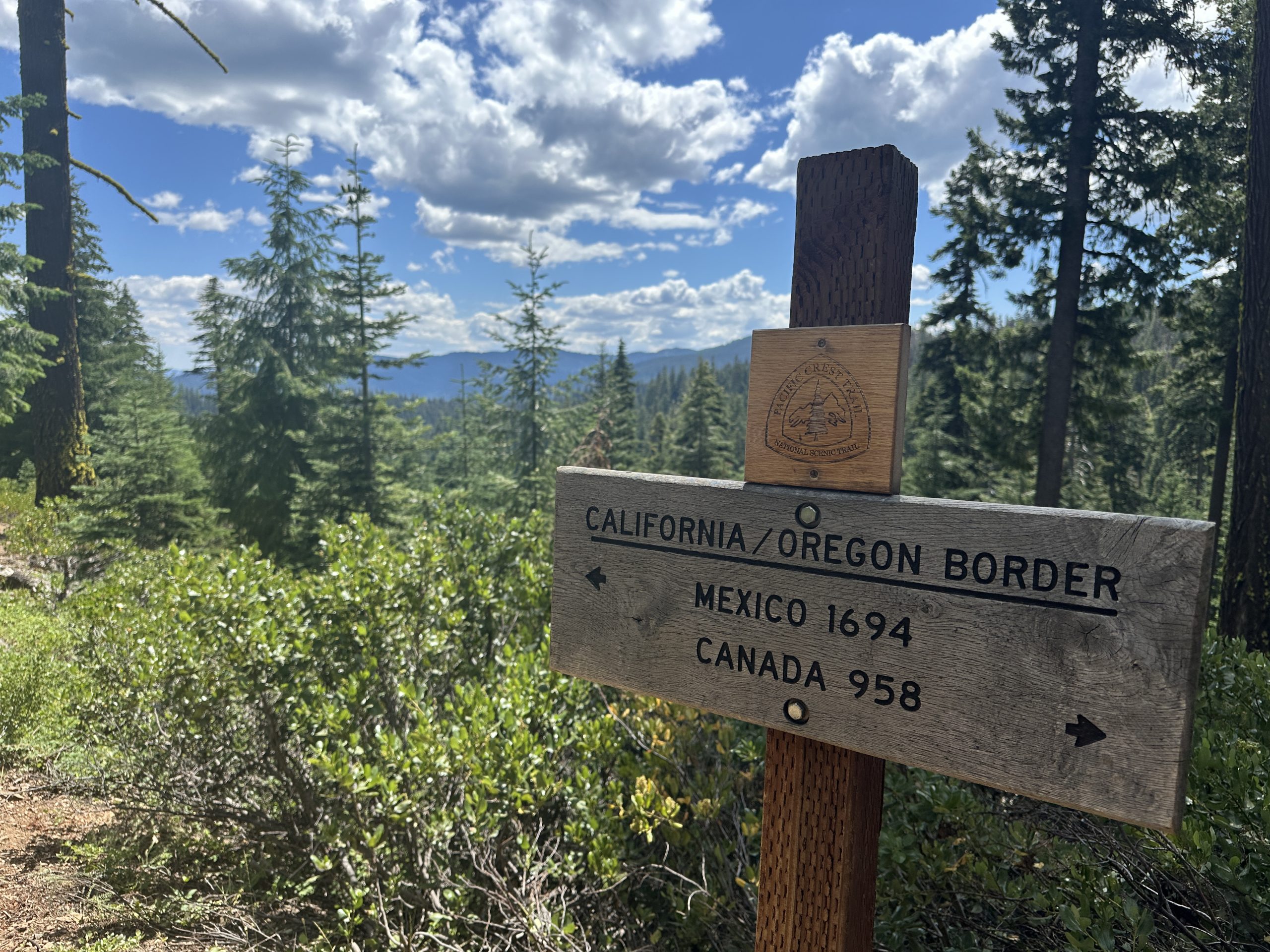
Greetings from Ashland, Oregon!
For many hikers who came from Mexico, entry into Oregon marks the end of their journey. Not literally, but the hardest part is complete and it’s clear sailing from here on out.
Even though I still have a ways to go, it’s still a fun milestone. I’m feeling stronger and stronger every day and while I don’t think I have my trail legs quite yet, I don’t feel quite as naïve as I did when I started. So for me, it’s like graduating from junior high and now I’m a freshman. Still so much to learn.
The PCT meanders so much, why can’t we just walk in a straight line?
One thing I noticed on this section more than any other, was the high rate of- how shall we say?- shortcuts.
The climb out of Seiad was about 6000 feet of climbing over about 10 miles. But, you could take a forest road which trimmed off 1000 feet of climbing and a few miles.
Everyone has their own definition of what constitutes hiking the PCT. Hike your own hike, they say. but I suspect that when you are so close to Oregon and being done, you are much more willing to bend your own definition of what you mean when you say, “I hiked the PCT.” Take a forest road and trim off a few miles? Hell, yeah! I was sometimes dismayed to find that hikers that had been behind me were suddenly ahead of me. Not that it’s a race or anything. I keep telling myself that. I certainly can’t take the “high road” (pun intended) because I also did this going into Castella, where the trail did this meandering switchback but a road went straight down cutting 3 miles off our journey.
An emotional moment
I had my first tears on the trail. I was hiking in the morning sunshine, listening to music – Tending the Spark by Heather Houston – just as I entered a peaceful shady wooded area. Somehow the combination of the music and lyrics and the beautiful woods raised up emotions. I was completely alone so let the tears fall uninhibited. I wasn’t really sure what I was crying about.
Here are the lyrics:
And we will care for each other
As the world around us unravels
And we will tend to the spark
Of hope that lives within our grieving hearts
And we are here now, in this present moment
Lifting our voices and hearts
And we are here now, we have come together
We are tending the spark of hope
Oh may it grow
And we will care for each other
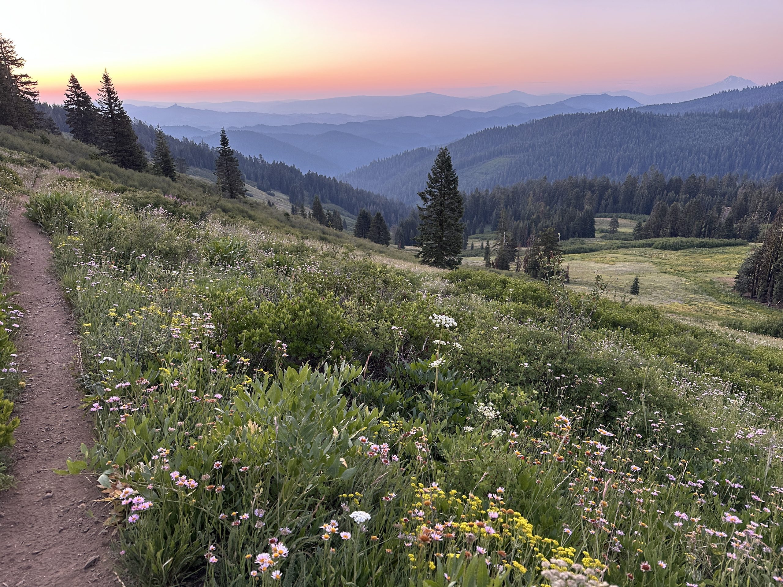
Ashland, here I come!
Coming down the mountains into Ashland was filled with amazing wildflower displays.
Thank you!
My husband T met me in Ashland and we enjoyed a zero day together. Two nights in a bed! What a luxury. I am so thankful for T for making all the arrangements and also dealing with the ever-growing list items to bring. Some gear and clothing are being changed out.
I’m also thankful to Mustard Patty for letting me use her resupply that she had sent to Seiad. It was fun to have some different snacks and meals than what I would normally pack. And while I can safely say that I prefer coffee to matcha, it did provide great energy on the trail (and made my poop green).
This website contains affiliate links, which means The Trek may receive a percentage of any product or service you purchase using the links in the articles or advertisements. The buyer pays the same price as they would otherwise, and your purchase helps to support The Trek’s ongoing goal to serve you quality backpacking advice and information. Thanks for your support!
To learn more, please visit the About This Site page.

Long admired as the go-to brand for durable, high-quality multitools in the outdoors, Leatherman has a new slate of knives that builds up their reputation by stripping things down. Its new premium fixed-blade and foldable knives are addition by subtraction—dedicated offerings for those who need the singular performance of a purpose-built outdoor knife.
The five knives in the collection include three fixed-blade knives—Rustle, Pioneer, and Trac—and two folding knives, the Glider and Blazer. All knives are fully customizable and made in the USA with MagnaCut® stainless steel to deliver durability, edge retention, and corrosion resistance. Each knife was created with a different type of outdoor enthusiast in mind.
Rustle: For the Camp Chef
If you’re more likely to count onions than ounces, the Rustle is the knife for you. Designed for early morning omelets and post-hike stir-fries, the Rustle’s thoughtful features make it perfect for outdoor cooking. The blade’s full bevel design with a slight curve toward the tip offers optimal slicing, especially when making thin cuts of meats and veggies. The santoku-inspired blade shape is also ideal for chopping, giving you everything you need to turn fireside chowdowns into five-star meals.
Weight: 4.3 oz
Width: 0.49 in
Blade length: 4 in
Total length: 8.3 in
Handle: G10 with blade jimping
Sheath material: Kydex
Pioneer: For the Survivalist
Building your own backcountry shelter requires a knife that’s totally reliable in the wilderness, and the Pioneer is an adventure partner that’s as tough as you. The blade’s heavy-duty, full-tang construction with a Japanese Tanto design offers trustworthy strength when cutting canvas, slicing through cording, or batoning wood. Field-ready features include an oversized lanyard hole to add a leash or cording and a handy notch on the jimping to strike a ferro rod when you need to get a fire going.
Weight: 8.3 oz
Width: .66 in
Blade length: 5 in
Total length: 10 in
Handle: G10 with blade jimping
Sheath material: Hybrid Kydex and full-grain American leather
Trac: For the Always-Outdoors
Whether you’re waiting for deer, a bite on your line, to stumble upon some mushrooms, or just the next job around the ranch, the Trac will be ready when you are. From foraging to fishing to farming, the versatile and well-balanced Trac knife is a worthy outdoor partner from sunup to sundown. Its rugged, hollow-ground blade was designed for tough tasks that still require precision, like field-dressing game. Because when you’re outside all day, the work should be as easy and accurate as possible.
Weight: 6.4 oz
Width: 0.62 in
Blade length: 4.2 in
Total length: 8.93 in
Handle: G10 with blade jimping
Sheath materials: Full-grain American leather
Glider and Blazer: For the Always Prepared
For you, “unprepared” may as well be a four-letter word. The Glider and Blazer folding knives are convenient enough to carry anywhere, reliable enough to always count on, and versatile enough for any task. Their supersleek design uses only 12 total components, resulting in fewer points of failure when you’re in the backcountry. A reversible, removable pocket clip makes them easy to carry anywhere and everywhere, and an attached lanyard with a built-in bit driver delivers extra versatility whether you’re setting up camp or setting up shop.
Weight: 3.7 oz
Width: 0.37 in
Blade length: 3.15 in (Blazer), 3 in (Glider)
Open length: 7.3 in
Closed length: 4.15 in (Blazer), 4.3 in (Glider)
Handle: Stainless steel with Cerakote® finish (except on Stainless Blazer model)
Founded in 1983 by Tim Leatherman, Oregon-based Leatherman Tool Group is the world’s largest manufacturer of high-quality multipurpose products with distribution in more than 86 countries. Built upon three principles—unwavering perseverance, ingenious design, and the ability to save the day—Leatherman has empowered people around the world to solve problems, big and small. Proudly based and manufactured in Portland, Oregon, the brand’s factory is located in the same building as the company headquarters. For more information, visit Leatherman.com.
-

 Brand Stories1 week ago
Bloom Hotels: A Modern Vision of Hospitality Redefining Travel
-

 Brand Stories2 days ago
CheQin.ai sets a new standard for hotel booking with its AI capabilities: empowering travellers to bargain, choose the best, and book with clarity.
-

 Destinations & Things To Do1 week ago
Untouched Destinations: Stunning Hidden Gems You Must Visit
-

 AI in Travel1 week ago
AI Travel Revolution: Must-Have Guide to the Best Experience
-

 Brand Stories3 weeks ago
Voice AI Startup ElevenLabs Plans to Add Hubs Around the World
-

 Brand Stories2 weeks ago
How Elon Musk’s rogue Grok chatbot became a cautionary AI tale
-

 Destinations & Things To Do2 days ago
This Hidden Beach in India Glows at Night-But Only in One Secret Season
-

 Asia Travel Pulse3 weeks ago
Looking For Adventure In Asia? Here Are 7 Epic Destinations You Need To Experience At Least Once – Zee News
-

 AI in Travel3 weeks ago
‘Will AI take my job?’ A trip to a Beijing fortune-telling bar to see what lies ahead | China
-

 Brand Stories3 weeks ago
ChatGPT — the last of the great romantics
You must be logged in to post a comment Login